Ever since the Olympics were over, it seems every week there is another piece of bad news about the Olympic Village. Its sad that such an amazing project has had a hard time selling. What's frustrating is that had the real estate market remained as hot as it was 2 years ago, no one would even be thinking about the place, except to comment on how well the city made out on the deal. Unfortunately, the units are simply too expensive for the average person to even consider buying there.
I think there is one other main factor in why the place isn't selling out, and that's the location. Although the village is close to downtown, it is surrounded by nothing. There is a lot of development already happening and lots more to come, but why was the village stuck dead in the middle of a vast, empty wasteland? It's not beside either of the Skytrain stations close to it (Main Street and Olympic Village) and the only bus line runs on 2nd Ave, at least a block away. Had it been located next to Cambie Street, in addition to the adjacent Skytrain station, it also would have benefit from all the great retail that already exists on Cambie Rise. Instead, Urban Fare and London Drugs keep pushing back their opening dates because there are no customers. It's frustrating that such a great project is located where it is.
Fortunately, even if the city does end up losing money on the project (which I highly doubt, even with the whole mess that's gone on), we have to look at the bigger picture. The city will be reaping significant property taxes from the project over the decades to come. In addition, the city still owns the vacant lands to the east and west of the site, on which they will no doubt make money having learned from the experience to date. The Olympic Village has also been a huge draw for private developers, and there are now several buildings built, under-construction or in the planning phase around the entire site. In the end, with those additional property taxes coming in, the city stands to make a huge gain over the long term. We just need to get the remaining units sold and get past this mess.
Saturday, November 6, 2010


Tuesday, September 7, 2010
Redevelopment of Marpole Safeway
Anyone who's driven from downtown to the airport knows this site at Granville and 70th...
I've been hearing about this project for a while and finally had a chance to go find the rezoning application. Safeway seems to be (finally!) redeveloping many of their urban sites, getting rid of those sprawling parking lots and densifying significantly. It's a smart move - because in the end they gain several hundred customers right overhead, and likely make a killing on the land they sell.
Anyways, go check it out here:
http://vancouver.ca/commsvcs/planning/rezoning/applications/8495granville/index.htm
I've been hearing about this project for a while and finally had a chance to go find the rezoning application. Safeway seems to be (finally!) redeveloping many of their urban sites, getting rid of those sprawling parking lots and densifying significantly. It's a smart move - because in the end they gain several hundred customers right overhead, and likely make a killing on the land they sell.
Anyways, go check it out here:
http://vancouver.ca/commsvcs/planning/rezoning/applications/8495granville/index.htm
Sunday, August 22, 2010
The Canada Line turns 1!

This past week the Canada Line celebrated its first birthday. I'm sure many remember the ridiculously long waits on that first day to ride the new trains for free. A few months later the lines were back for the Olympics, and the Buzzer Blog has some great pics...I can't believe how long the lines were!
The Buzzer Blog: Canada Line and the Olympics
Thursday, August 19, 2010
Cruise ship or floating sewer?

I can't believe it's been nearly 4 months since I posted...where has the time gone!?
Anyways, came across this article on cruise ships...I've always been very skeptical of cruises as a method of travel. With good reason, by the looks of it.
Green Cruising?
http://invw.org/green_cruising
Saturday, April 24, 2010
Bringing Car-free Streets to Vancouver

Anyone that has been to Copenhagen (and many other European cities) knows how great the pedestrian streets are. So many people walking and biking, sitting on patios and in cafes, such a great place for people watching. It's surprising that Vancouver doesn't have more streets like this, seeing as we are trying to become the world's greenest city. The redesigned Granville Street will go along way in starting such a movement here, but I think we need to look longer term. This is what I see as a future car-free network in downtown (in blue):
 These routes are already great pedestrian streets in Vancouver - Robson, Davie, Denman and Granville. So great, in fact, that at times there is not enough room for all the people walking along it. Think of Robson on a warm sunny weekend day - people are bumping into each other making their way along. It only makes sense to take advantage of this fact, and give pedestrians more room to move. Let's face it, no one drives along Robson Street to actually get anywhere - so let's start a gradual transition to remove the cars.
I'm not saying that overnight we should shut the street down to cars. Doing that would leave us with what Granville Street was up until recently - a dead zone. Instead, like they did in Copenhagen, the closure should be very gradual.

1. Start by giving more space to pedestrians where it makes sense: at bus stops, intersections, mid-block crossings on longer blocks, and anywhere pedestrians always seem to bunch up. Many of these ideas were recently incorporated into a redesign of Main Street. This could also be considered a sort of traffic calming.

2.Then start taking away on-street parking spots, just a few percent each year. So few are taken that drivers don't even notice. Take those spots and turn them into pedestrian space.

3. Close a block here and there. Maybe only one or two each year, starting with those that make obvious sense. For example, at Robson Square, which is very narrow already. This gives drivers time to adapt to new routes, and eliminates major traffic issues. It also allows the city to deal with problems gradually, should they arise.

4. Over the course of about 20 years, a network of car-free routes forms, meaning people can walk or bike right in the city without cars in their way. Streetcars also work well into this plan, and could run along the centre of the streets.

In Vancouver, the obvious place to start is Robson Street. The section between Bute and Granville, in particular, is a perfect candidate for "pedestrianization". Start with bus and pedestrian bulges, and remove a few parking spaces at key points to widen the sidewalk (in front of Cafe Crepe near Burrard, for example). A "scramble crossing" at Burrard and Robson would make pedestrian crossing easier and move traffic more effectively.

Next, move onto Davie and Denman - the sidewalks on these streets are just too narrow for the number of people walking along most sections. Eventually join all four streets to form a network of pedestrian streets and over time close them off to cars. It may take 20-30 years, but other cities have proven it works and with great results.
Tuesday, April 20, 2010
Why the Site C Dam is So Wrong
The BC government announced yesterday that a massive, $6.6 billion hydro-electric dam (being called "Site C") on the Peace River in Northern BC is a go. At first glance you may think "hey, hydro, that's green power. Perfect!" And yes, hydro is and can be very green power. The main problem with Site C is its massive size.
BC Hydro Site C Web-page
Here's why the current plan for Site C is terrible...
A great series of articles from The Tyee goes into detail on the downsides of building this dam - check it out!
Disturbing the Peace: The Case Against the Site C Dam
BC Hydro Site C Web-page
Here's why the current plan for Site C is terrible...
- Dams of this size create reservoirs that cause massive destruction to the land and never really become the "lake" we are promised. We need only look at the effects from the W.A.C. Bennett dam that was built in the 60s to see that.
- This dam is going to flood over 5000 hectares of land, virtually all of it fertile land that either is currently or could be farmed. It makes no sense to flood fertile land in an age where food security and availability is becoming an increasingly critical issue. This land is as productive as the Lower Mainland because of the long summer days they get this far north.
- There are so many other ways to produce this much power: smaller dams like run-of-river systems, wind, geothermal, solar, tidal. We have all of these available to us (in virtually unlimited quantities) in BC, so why is the government stuck on a single massive project?
- We don't need more power, at least not this much. BC Hydro and the government will tell you that BC now has to import about 15% of its power, which is creative accounting. The fact is BC Hydro sells lots of green power at a premium to the US, and buys cheaper dirty power to make up for what we need. In addition, BC Hydro admits they plan to achieve 70% of future power needs through energy conservation. I think that number can be even higher - the problem in this province is that our power is far too cheap, leaving little incentive to conserve.
- The Site C dam is no where near where most of the power is being used. Approximately 13% of the power generated 1000's of km away in the Peace is lost during transmission. We should be looking at generating more power near to and within the Lower Mainland.
- Finally, there's the cost. $6.6 billion? Really? How can we justify spending this much when private companies are falling over each other trying to develop green power in this province at no cost to the taxpayer?
A great series of articles from The Tyee goes into detail on the downsides of building this dam - check it out!
Disturbing the Peace: The Case Against the Site C Dam
Monday, April 12, 2010
Making-over The Bay

A few weeks ago I stumbled across this picture that was taken in the 1930s/40s of the Hudson's Bay Company building (The Bay) here in Vancouver. I love old photos and historical architecture in general, but this picture struck me. It struck me because of how much the building had been butchered and defaced by poor design decisions in the time since. To compare, look at a picture from a similar angle taken today:

All the upper windows have been covered over. One column of windows has been transformed into ventilation grilles (which are dirty, of course).
 The awnings over each street-level window and the large canopies over each entrance have been replaced by an ugly, oppressive overhang. Sure, the overhang is great for protection from the rain, but it's dark and uninviting beneath. Without the entrance canopies, who can tell where to enter the store unless you're walking right in front?
The light standards that used to line the parapet are gone. Even the signage is bad - a suburban fluorescent sign-box on the corner of the building.
These pictures taken at night also show the contrast between then and now:


 The modern exterior lighting treatment is pretty great, I must admit. But the windows, the eyes of any building, are dead and lifeless. In the old photo, the building has a life, a soul, it's a place you might actually want to enter.
Fortunately modern architects have realized past mistakes such as this. Natural light has made a comeback, windows are a must, and they even open! The street-scape and pedestrian environment are key elements of any new building design today, much as they were when The Bay was originally built. I guess this post is an attempt to convince "the powers that be" to bring back the character of the original building, which is arguably one of the most beautiful in this concrete and glass city.


Tuesday, April 6, 2010
The new Granville Street

The more times I walk down the refurbished Granville Street here in Vancouver, the more I like some aspects and dislike others. The lighting is great as are the materials used for the sidewalks and street furniture. The extra wide sidewalks and bus-only sections on the northern half are wonderful. But the decision to park cars the way they have between Nelson and Drake is, well, dumb. Part of the goal of this refurbishment was to widen the sidewalks, and because of the parking the way it is, I think it has failed.
Granville Street Redesign: City of Vancouver

The idea was right in principle: that cars could park on half the sidewalk most of the time, and be banned for special events or busier times, leaving four clear lanes of traffic. In reality though, when the cars are removed, all the posts and plantings that are there to define the parking spots make it hardly walkable, adding no additional space to the sidewalks. In simple terms: FAIL.
Fortunately there is an easy solution: put the cars back on the road! Granville Street doesn't even seem to have the volume of traffic that warrants 4 full lanes, particularly with the one-way couplet of Seymour and Howe on each side. In addition, Granville ends at Smithe for cars, (only buses can go north beyond that point), so it's not a street that is used to get anywhere. So let's fix this: put the parking onto the roadway where it makes sense, and clear up all the clutter that is there for parking cars to make the southern-end sidewalks as great as the rest of the street.

Thursday, January 21, 2010
Totally connected, yet so disconnected
On an episode of Oprah last week (and a few last fall), a family of four was profiled. They were the typical suburban family; Mom, Dad and two sons. The issue was how the family was so distant from one another, and how the marriage was at risk of falling apart. The reason: not enough social interaction. They rarely ate meals together or did anything together aside from watch TV - hardly good family bonding. Mom and Dad shared a bed, but that was about it.
The cause: electronics. Mom, Dad and the older son all had cell phones, and were texting or checking email constantly. The son was sending 200-300 texts every day! Video games and the TV served as a babysitter. The first thing dad did every morning was get up and check his email. Instead of interacting with each other, they were interacting with others who weren't even in their home. The house was also a mess and the garage was full of stuff; not on the level of "Hoarders", but at a level of over consumption typical in this age of consumerism. This family, and all of us these days, are more connected to the world than ever before, yet socially we are becoming very disconnected from each other.
So to solve the problem, the electronics were taken away for a week, and rules were set about cleaning the house, eating together, spending quality time together, etc. And it worked - in just a few days, things improved more than anyone expected. Talking to each other instead of to their cell phones made a huge difference.
That should be the end of the story, right? Well, I think it's great that this family worked it out, and I hope a lot of families learned from it. But I think this experiment only cured a symptom of a bigger problem. This family, as I mentioned, is a typical suburban family. "Suburban" being the key word. The kids rarely went to hang out with friends, and why? Probably because being in suburbia, they are just too far away. Kids in suburbia often can't just walk a few houses down to see friends like they can in the city - everyone is too spread out. Mom and Dad had to drive to get anywhere or do anything, and after a long day at work and a long commute, who wants to get back in their car again? So, they pull into the garage and stay in the house, isolated.
The real problem is the design of suburbia. Suburbia, which was once a great idea, is becoming a nightmare. Kids are isolated and if they can't drive or don't have a car, they are stuck at home. That leads to boredom, obesity and social problems - kids will find something to do eventually, and more and more often it's crime and drugs. People would walk or bike if they could, but everything is so spread out, it's not going to happen. And it's not just the distance, it's the blandness of the surroundings. Walking through suburbia, past garage door after garage door, one cookie cutter house after another, is hardly motivation to do it more than once. There's no interest to get people out of their homes. So they stay inside, the streets void of people.
"Suburbia" is the problem that needs to be solved. I'm not saying everyone has to live downtown in highrises, but we need to stop building anonymous suburbs. It is possible to design communities of single family homes where you don't have to drive everywhere, where there are people on the streets, shops close by, life. Governments need to start promoting and even mandating good development - people who aren't isolated are healthier physically and mentally and the less we drive, the fewer roads we need. Those bland 'burbs are cheap to build initially, but have become very expensive in the long run.
The cause: electronics. Mom, Dad and the older son all had cell phones, and were texting or checking email constantly. The son was sending 200-300 texts every day! Video games and the TV served as a babysitter. The first thing dad did every morning was get up and check his email. Instead of interacting with each other, they were interacting with others who weren't even in their home. The house was also a mess and the garage was full of stuff; not on the level of "Hoarders", but at a level of over consumption typical in this age of consumerism. This family, and all of us these days, are more connected to the world than ever before, yet socially we are becoming very disconnected from each other.
So to solve the problem, the electronics were taken away for a week, and rules were set about cleaning the house, eating together, spending quality time together, etc. And it worked - in just a few days, things improved more than anyone expected. Talking to each other instead of to their cell phones made a huge difference.
That should be the end of the story, right? Well, I think it's great that this family worked it out, and I hope a lot of families learned from it. But I think this experiment only cured a symptom of a bigger problem. This family, as I mentioned, is a typical suburban family. "Suburban" being the key word. The kids rarely went to hang out with friends, and why? Probably because being in suburbia, they are just too far away. Kids in suburbia often can't just walk a few houses down to see friends like they can in the city - everyone is too spread out. Mom and Dad had to drive to get anywhere or do anything, and after a long day at work and a long commute, who wants to get back in their car again? So, they pull into the garage and stay in the house, isolated.
The real problem is the design of suburbia. Suburbia, which was once a great idea, is becoming a nightmare. Kids are isolated and if they can't drive or don't have a car, they are stuck at home. That leads to boredom, obesity and social problems - kids will find something to do eventually, and more and more often it's crime and drugs. People would walk or bike if they could, but everything is so spread out, it's not going to happen. And it's not just the distance, it's the blandness of the surroundings. Walking through suburbia, past garage door after garage door, one cookie cutter house after another, is hardly motivation to do it more than once. There's no interest to get people out of their homes. So they stay inside, the streets void of people.
"Suburbia" is the problem that needs to be solved. I'm not saying everyone has to live downtown in highrises, but we need to stop building anonymous suburbs. It is possible to design communities of single family homes where you don't have to drive everywhere, where there are people on the streets, shops close by, life. Governments need to start promoting and even mandating good development - people who aren't isolated are healthier physically and mentally and the less we drive, the fewer roads we need. Those bland 'burbs are cheap to build initially, but have become very expensive in the long run.
Tuesday, December 29, 2009
Trains in Canada slower now than 40 years ago
This is really frustrating.
In 1968, CN's Turbo Train started service and easily reached 269 km/h on its first commercial Montreal-Toronto run. Despite some technical issues, the trains operated until the 80's and the express Montreal-Toronto trip took 4 hours and routinely hit 160 km/h.
In 1982 the Turbo Trains were replaced by LRC trainsets (operated by VIA). The engines have been replaced, but the passenger cars remain in use today. They achieved a maximum speed of 208 km/h. In commercial service, however, due to limiations of the tracks and wear caused by these trainsets, they are limited to 160km/h. Today, an express Montreal-Toronto trip takes 4 hours and 30 minutes.
Does anyone else see a problem here? And this doesn't even address the fact that passenger service doesn't really even exist east of Ontario.
In 1968, CN's Turbo Train started service and easily reached 269 km/h on its first commercial Montreal-Toronto run. Despite some technical issues, the trains operated until the 80's and the express Montreal-Toronto trip took 4 hours and routinely hit 160 km/h.
In 1982 the Turbo Trains were replaced by LRC trainsets (operated by VIA). The engines have been replaced, but the passenger cars remain in use today. They achieved a maximum speed of 208 km/h. In commercial service, however, due to limiations of the tracks and wear caused by these trainsets, they are limited to 160km/h. Today, an express Montreal-Toronto trip takes 4 hours and 30 minutes.
Does anyone else see a problem here? And this doesn't even address the fact that passenger service doesn't really even exist east of Ontario.
Thursday, November 5, 2009
Hockey at BC Place?

I wonder if VANOC ever thought of this: why not host the Olympic hockey finals at BC Place instead of GM Place? This is Canada, after all, and Olympic hockey tickets are as hot as, if not hotter than, opening ceremony tickets. Filling the 60,000 seats at BC Place should be easy and make them a fortune. I don't know the details of the opening/closing ceremonies, but we can be fairly certain there is going to be some sort of a temporary ice rink in there anyways for the performances at the ceremonies - so making it work for a game would be easy. The NHL has found great success now with their annual Winter Classic hockey games, so the concept is proven - and in BC Place, players wouldn't have to contend with -18C temps like they did when Edmonton hosted the Heritage Classic in 2003.
Hey VANOC - is it too late to reconsider?
Wednesday, November 4, 2009
Portland to become North America's Copenhagen?
The City of Portland, OR is setting itself a very lofty, yet attainable goal: to achieve the same level of bike ridership as Copenhagen. Right now Portland is tops in North America for bike ridership, with about 8% of all commutes by bike. By comparison, 37% of commutes in Copenhagen are by bike (and of ALL trips taken, 55% are by bike). They've done it by gradually taking away parking spots for cars (about 3%/year, which drivers don't even notice on an annual basis) and adding separated bike lanes along major arteries. Portland has already started implementing the same strategies and it's obviously working.
Bikes: Viagra for the Urban Landscape
There are a few complaints from drivers that come up of an over against making more space for bikes:
To wrap-up, some interesting facts:
Car emissions kill about 30,000 people each year in the U.S.
(American Lung Association, Oregon Traffic Commission, Association of Commuter Transportation, American Automobile Association, and City of Eugene.)
The energy and resources needed to build one medium-sized car could produce 100 bicycles.
95% of a car's energy goes towards moving the car itself, and only 5% to moving the passenger.
External costs of driving. The estimated annual external cost of driving (including air pollution, climate change, imported oil security, congestion, accidents, noise, etc.) is $126.3 billion.(E Magazine, 2005)
It costs about $50 to build and maintain one space in a bike rack and $500 for a bike locker, yet one car parking space in a typical parking structure costs about $8,500. An underground spot in a downtown Vancouver condo tower costs about $30,000 to build.
90% of children who lived within a mile of their school walked or biked to school in the 1960's. Only 31% do so today. (Salon, 2004)
Bikes: Viagra for the Urban Landscape
There are a few complaints from drivers that come up of an over against making more space for bikes:
- Bikes aren't paying for the space they use like cars are.
- We get winter here and lots of rain, so you can only bike for a few months of the year - so why are we wasting the space for bike lanes?
- Removing lanes for bikes means traffic gets worse - all those cars are sitting there are spewing more pollution than if they could move quickly.
To wrap-up, some interesting facts:
Car emissions kill about 30,000 people each year in the U.S.
(American Lung Association, Oregon Traffic Commission, Association of Commuter Transportation, American Automobile Association, and City of Eugene.)
The energy and resources needed to build one medium-sized car could produce 100 bicycles.
95% of a car's energy goes towards moving the car itself, and only 5% to moving the passenger.
External costs of driving. The estimated annual external cost of driving (including air pollution, climate change, imported oil security, congestion, accidents, noise, etc.) is $126.3 billion.(E Magazine, 2005)
It costs about $50 to build and maintain one space in a bike rack and $500 for a bike locker, yet one car parking space in a typical parking structure costs about $8,500. An underground spot in a downtown Vancouver condo tower costs about $30,000 to build.
90% of children who lived within a mile of their school walked or biked to school in the 1960's. Only 31% do so today. (Salon, 2004)
Friday, October 30, 2009
Sqaumish Oceanfront Development
Over the past two years I've been following with great interest the development of downtown Squamish and the Oceanfront lands, which were formerly industrial. As much as Squamish gets made fun of, you can't argue that it isn't incredibly beautiful.
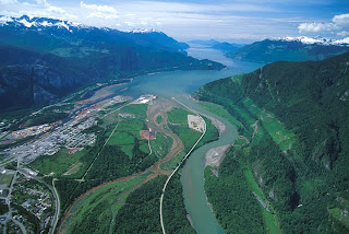
It's in an ideal location, on the delta of a river, at the end of a fjord, on the Pacific Ocean, half-way between Whistler and Vancouver. I've wondered whether I could live there, being so close to two of my favorite places, and surrounded by the mountains. With the development that has happened downtown, and with what is proposed, I feel I could. The community is starting to grow smart, sustainably. There is a new ski resort proposed for Brohm Ridge, on the north side of town. The town is surrounded by the outdoors, by nature.
That ideal location, though, also bugs me. I can't get past the fact that all of this development downtown and on the oceanfront is barely above sea level. I feel the same way about Richmond and Delta. Yes, there are dikes and pumps to keep the water out, and upgrades, improvements and expansion to both are planned, but I'm still uneasy about it all. Have we learned nothing from Galveston and New Orleans? We don't get hurricanes (yet), but we do get some good winter storms now and then, and a lot of rain all winter long. Look at London having to control the Thames, and the Netherlands having to protect almost the entire country with major flood control systems. Do we want to end up in that position? The District even admits in their preliminary document that sea level rise is a concern that will need to be addressed.
To their credit, the District of Squamish does have some design guidelines to help when there is a flood. In residential projects, the first floor (at street level) is parking and commercial. Due to the high water table, underground parking isn't an (affordable) option. But that still leaves plenty of opportunity for property damage.
So I wonder if it's possible to go even further. Let's face it, at some point there is going to be a storm bad enough to cause a flood, and if it's bad enough, the pumps are going to stop working, or the dikes won't be high enough, or both. We could:
1. Add lots of fill to raise the height of the land (very expensive)
2:Plan for a flood in a way that won't rely on emergency systems.
What if the water came in, and it wasn't really that big a deal. I'm not saying to become Venice, because it has it's own problems, after all. But what if, similar to Venice, the water stayed in canals where it belonged. What I'm picturing, in fact, is a street cross-section like Yaletown. Wide sidewalks on either side of the street that are raised about 6 feet above the road.
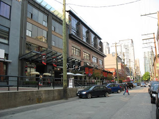
Cars drive and park on the road (and under the buildings at this same level), but pedestrians, businesses and residences are separated from and raised above it. Should the tide come over the dike or the rain come down in a deluge, the water runs into the streets (canals), which store it as needed for the pumps to keep up. Only the cars are at risk, and they can be driven to higher land should the situation call for it. The streets would function much like a stormwater retention pond, but would only be needed in the most significant storms.

At the end of each block, ramps for wheelchairs are available to access the sidewalks from the street. Spaced along the length of the block there are stairs to street level just like in Yaletown. Side streets could even be bridged at sidewalk level for pedestrians, and allowing just enough clearance for cars to get under, but keeping trucks on the main roads. Overall, the entire solution is very low-tech and much more sustainable than continuing to raise the dikes and build an infrastructure of pipes and pumps for something that should only happen a few times each century. Yaletown was born from an industrial area, and downtown Squamish and the oceanfront lands in particular are also rising out of an industrial past, so the design makes sense. Above all, it creates a great street environment, as is proven in Yaletown.

It's in an ideal location, on the delta of a river, at the end of a fjord, on the Pacific Ocean, half-way between Whistler and Vancouver. I've wondered whether I could live there, being so close to two of my favorite places, and surrounded by the mountains. With the development that has happened downtown, and with what is proposed, I feel I could. The community is starting to grow smart, sustainably. There is a new ski resort proposed for Brohm Ridge, on the north side of town. The town is surrounded by the outdoors, by nature.
That ideal location, though, also bugs me. I can't get past the fact that all of this development downtown and on the oceanfront is barely above sea level. I feel the same way about Richmond and Delta. Yes, there are dikes and pumps to keep the water out, and upgrades, improvements and expansion to both are planned, but I'm still uneasy about it all. Have we learned nothing from Galveston and New Orleans? We don't get hurricanes (yet), but we do get some good winter storms now and then, and a lot of rain all winter long. Look at London having to control the Thames, and the Netherlands having to protect almost the entire country with major flood control systems. Do we want to end up in that position? The District even admits in their preliminary document that sea level rise is a concern that will need to be addressed.
To their credit, the District of Squamish does have some design guidelines to help when there is a flood. In residential projects, the first floor (at street level) is parking and commercial. Due to the high water table, underground parking isn't an (affordable) option. But that still leaves plenty of opportunity for property damage.
So I wonder if it's possible to go even further. Let's face it, at some point there is going to be a storm bad enough to cause a flood, and if it's bad enough, the pumps are going to stop working, or the dikes won't be high enough, or both. We could:
1. Add lots of fill to raise the height of the land (very expensive)
2:Plan for a flood in a way that won't rely on emergency systems.
What if the water came in, and it wasn't really that big a deal. I'm not saying to become Venice, because it has it's own problems, after all. But what if, similar to Venice, the water stayed in canals where it belonged. What I'm picturing, in fact, is a street cross-section like Yaletown. Wide sidewalks on either side of the street that are raised about 6 feet above the road.

Cars drive and park on the road (and under the buildings at this same level), but pedestrians, businesses and residences are separated from and raised above it. Should the tide come over the dike or the rain come down in a deluge, the water runs into the streets (canals), which store it as needed for the pumps to keep up. Only the cars are at risk, and they can be driven to higher land should the situation call for it. The streets would function much like a stormwater retention pond, but would only be needed in the most significant storms.

At the end of each block, ramps for wheelchairs are available to access the sidewalks from the street. Spaced along the length of the block there are stairs to street level just like in Yaletown. Side streets could even be bridged at sidewalk level for pedestrians, and allowing just enough clearance for cars to get under, but keeping trucks on the main roads. Overall, the entire solution is very low-tech and much more sustainable than continuing to raise the dikes and build an infrastructure of pipes and pumps for something that should only happen a few times each century. Yaletown was born from an industrial area, and downtown Squamish and the oceanfront lands in particular are also rising out of an industrial past, so the design makes sense. Above all, it creates a great street environment, as is proven in Yaletown.
Monday, October 26, 2009
Vancouver's Downtown Streetcar

For those of you that haven't heard, the City of Vancouver is planning a downtown streetcar. "Phase 0", aka the Olympic Line, will run from Granville Island to the Olympic Village during the games, and will be free! The full plan for the future streetcar system is right here:
Downtown Streetcar Design and Alignment Report
I think this is a great idea, but I don't think it goes far enough. Why does the Pacific Blvd. line terminate at Drake and Granville? Why does it go along Drake at all? Why doesn't the line serve the West End at all? The Sky Train does a great job of serving downtown overall, but the West End is served only by buses, which are often full - a streetcar line would be a great solution and would have an immediate ridership.
Also, despite being slightly more expensive overall (yes, the capital expense is higher, but operating costs are lower), the streetcar is proving to be a preferred transit choice, as it attracts much more ridership and spurs development in the area - Portland is a great example of this. The lesson they have learned is that streetcar lines, because they are a permanent investment, are much better at generating new development than buses. A bus route could change at any moment - but once tracks for a streetcar are in place, you know it's not going away.
The city also realizes that continuing the line down Arbutus Street (along an existing rail corridor) is also an option for the future, and one that makes a lot of sense. Connections to the Millennium Skytrain Line, both current (at VCC/Clark Dr.) and the future extension along Broadway to UBC make this line even more feasible.
Anyways, here's my proposal for the future streetcar line downtown:

Routing the streetcar like this puts ALL of the downtown peninsula within a 5-10 min. walk of either a streetcar stop or a skytrain station. Streets like Davie, Denman and Robson stand to gain big benefits from having the line along them - new development at higher density (4-6 storey buildings instead of the current 1-2 storey shops), more pedestrian traffic, etc. It might make sense to take a line along Granville street to South Granville as well, because it is still a major shopping and business street, with the B-line to the airport now gone due to the Canada Line.
The line down Robson Street would work great in conjunction with its gradual conversion to a pedestrian street, particularly in the already busy Jervis-to-Seymour section. The car traffic barely moves at busy times right now, and pedestrians are nearly squeezing off the sidewalks, so closing that section to cars makes a lot of sense. This route also takes advantage of streets that are already busy transit routes, so there is guaranteed to be ridership from day one.
And in the very long term, it may make sense to take the line right over the Lion's Gate bridge to West Vancouver - but I know that's really stretching it. Even better would be a tunnel continuing the Canada Line to Lonsdale to eliminate the Seabus, and then a dedicated streetcar along the north shore linking North Vancouver and West Vancouver...but that's a topic for another day.
Thursday, October 22, 2009
An Ecotopia for Climate Protection
There are so many pessimists out there that say it just can't be done, we just can't possibly become carbon neutral, there's no way we'll make it, it's too late to stop global warming. I've never believed any of that, but evidence to refute the naysayers is hard to come by. Well here is a story that shows it is possible, and it's not hard to do or even that expensive.
An Ecotopia for Climate Protection: Samso Island Is Face of Danish Green Revolution
Samso is a small community, but cities and agricultural communities working together can become a perfect system - a balanced economy of energy that results in a net zero effect on the environment. Metro Vancouver is a perfect place to create such an economy - we have vibrant and increasingly dense, sustainable cities right next door to the most productive farmland in Canada, mountains with endlessly renewable supplies of wood and fresh water, and an ocean and all the life and energy it produces. Metro Vancouver is the perfect place to take Samso's idea and scale it to a major region.Tuesday, October 20, 2009
What to do with the viaducts

Anyone living in Vancouver knows them - the Georgia and Dunsmuir viaducts on the east end of downtown. The original Georgia viaduct was built in about 1915. It was notoriously unsafe having been built on the cheap and was finally replaced in the early 1970s with the current structures, which were part of the intended freeway plan for the city. Fortunately the rest of the freeways never got built, but these remain. With the viaducts scheduled to be closed during the duration of the Olympics in February, many are questioning how necessary they really are and what could be done to improve them assuming they are kept.
One popular idea is to tear them down. Structurally they are sound, but should a big enough earthquake occur and knock them down (a very real possibility), would we really rebuild them? The city's transportation department probably says yes, but I think the vast majority of the population begs to differ. So why are we keeping them? Councillor Geoff Meggs has written a thought provoking article for The Tyee with this very suggestion: "Time for Vancouver to Tear Down Its Viaducts?" Obviously this can't be taken lightly, as it means new connections would be needed in the road network between the higher-elevation downtown and the lower-elevation False Creek flats, but that certainly isn't impossible. Removing the viaducts frees up valuable land owned by the city for development.
How about an elevated park? Close them to regular traffic, but not tear them down. The views from the viaducts are some of the best in the city because they are elevated above the surrouding buildings and there is little development immediately around them. Using New York's High Line as an idea, why not transform these roads into raised parks with walking paths, bike lanes, gardens and more. Development around the viaducts could be promoted to work in conjunction with the parks and preserve the views.
Finally, maybe we don't tear them down and don't significantly change the viaducts, but we develop around and beside them in a way that makes them streets people want to be on. This has already been started with the Spectrum project by Concord Pacific at the west end of the viaducts. At viaduct (upper/downtown) level there are now wide sidewalks with trees fronted by townhomes. Above the townhomes are 4 - 35 storey condominium towers. The sidewalks provide access to GM Place and via stairs access to the lower level and False Creek. At the lower level. below the Spectrum towers, is parking and a full size Costco store, accessed by the "other" city grid (Expo and Pacific Blvds.) Why can't this type of development take place between the viaducts for their full length, adding wide sidewalks with townhomes and/or retail on the upper level, giving pedestrians and cyclists a reason to travel along the viaducts, and connecting the east end. On the lower level retail and offices, adding life to those streets as well. Shops and cafes on Pacific Blvd. could be sheltered by the viaduct overhead, but still get sun because they face south. They'd have a great view to the future Creekside Park. Here's a very quick sketch of what I'm trying to describe.

With the development that is soon to start happening in this area (North East False Creek), now's the time to be debating what to do with these structures. The only thing I do know for sure is that the viaducts are they are now are serving only one purpose, and not very elegantly at that. Just about anything we can do will improve them and make them an asset instead of a burden.
Thursday, October 8, 2009
My view on "Views on Views"
On Monday night I attended "Views on Views", a lecture/debate about the current review of Vancouver's protected view corridors hosted by SFU's City Program. The discussion was lively and both sides of the argument made good points. I previously thought the view corridors in general were a good idea, but that a lot of them were pointless for how little a view they gave. After the lecture, I must admit, my "view" has changed. Here's why:
1. Although a protected view is based on standing at a certain point, and is just a glimpse from that point, views are dynamic, so as you're walking or driving along, you're seeing more than just that slim shot.
2. Most of the small glances are from along the south shore of False Creek looking towards the north shore. The downtown blocks most of the mountains, but these views give glimpses to the mountains. And lets face it, without those glimpses the monotony of the glass towers in that part of the city would be overwhelming. The views remind us where we are and distract us from what is otherwise a wall of buildings.
3. The view corridors really haven't prevented any projects from being realized, and in fact you could argue that a building like the Shangri-La ended up more beautiful because it was forced to become triangular in shape to avoid a view corridor. As an architect I can attest that the best projects are often the ones that have the most challenges, because you are forced to become even more creative than you already are. The Ritz Carlton tower also twisted the way it did in order to avoid the view corridor on it's higher levels.
4. We have a lot more land yet to develop in this city to be worried only about how much space there is downtown to continue to grow. (That was the main reason the corridors were brought up for review - to see if there was any opportunity for more and/or taller towers downtown). In particular, the area east of downtown all the way to Clark Drive was pointed out as a prime area for development, negating any need to allow bigger buildings downtown.
Those are the points that struck a chord with me. There were good arguments on the other side
as well, such as allowing buildings to go taller into the view corridors requires them to be slimmer, blocking less of the view and creating more public space at ground level. But as Larry Beasley put it best, once the views are gone, they are gone, and it only takes one building to do that.
There are still a few open houses happening before the Planning Department makes their presentation to council, so go check them out and give your opinion. Apparently there has already been a lot of support expressed for actually adding view corridors, and now is the time to do it, before downtown starts expanding east.
Open Houses:
1. Although a protected view is based on standing at a certain point, and is just a glimpse from that point, views are dynamic, so as you're walking or driving along, you're seeing more than just that slim shot.
2. Most of the small glances are from along the south shore of False Creek looking towards the north shore. The downtown blocks most of the mountains, but these views give glimpses to the mountains. And lets face it, without those glimpses the monotony of the glass towers in that part of the city would be overwhelming. The views remind us where we are and distract us from what is otherwise a wall of buildings.
3. The view corridors really haven't prevented any projects from being realized, and in fact you could argue that a building like the Shangri-La ended up more beautiful because it was forced to become triangular in shape to avoid a view corridor. As an architect I can attest that the best projects are often the ones that have the most challenges, because you are forced to become even more creative than you already are. The Ritz Carlton tower also twisted the way it did in order to avoid the view corridor on it's higher levels.
4. We have a lot more land yet to develop in this city to be worried only about how much space there is downtown to continue to grow. (That was the main reason the corridors were brought up for review - to see if there was any opportunity for more and/or taller towers downtown). In particular, the area east of downtown all the way to Clark Drive was pointed out as a prime area for development, negating any need to allow bigger buildings downtown.
Those are the points that struck a chord with me. There were good arguments on the other side
as well, such as allowing buildings to go taller into the view corridors requires them to be slimmer, blocking less of the view and creating more public space at ground level. But as Larry Beasley put it best, once the views are gone, they are gone, and it only takes one building to do that.
There are still a few open houses happening before the Planning Department makes their presentation to council, so go check them out and give your opinion. Apparently there has already been a lot of support expressed for actually adding view corridors, and now is the time to do it, before downtown starts expanding east.
Open Houses:
http://www.vancouver.ca/viewsThursday, October 15: 4 - 8 pm
Saturday, October 17: 10 am – 5 pm
Sunday, October 18: 12 - 5 pm
Vancouver Public Library
Central Branch
350 West Georgia StreetTuesday, October 20: 6 - 9 pm
False Creek Elementary
900 School Green
Monday, October 5, 2009
Wednesday, September 23, 2009
Some cool facts and stats
Just a bunch of interesting facts I've come across recently...
- The Cache Creek Landfill (where Metro Vancouver's waste is taken) produces enough methane (biogas) that it could power all the trucks that ship our garbage there. Right now, though, that gas is simply burned off.
- All the Waste-to-energy plants (incinerators) in Sweden combined release fewer dioxins into the air than a single fireworks show at the Celebration of Light here in Vancouver. We have at least four of those shows a year, and yet people are worried about the emissions from additional W2E plants.
- In the US alone, in the past 30 years, over 1 trillion aluminum cans have been thrown into landfills - that aluminum is worth over $20 billion!
- North Americans have double the "ecological footprint" of Europeans and 7 times the average of Asians and Africans.
- The population of Vancouver and the Lower Fraser Valley (approx. 2 million people) depends on an area equivalent to 19 times that which is within our boundaries for our food, forestry products, carbon dioxide absorbtion and energy. What would we have to do to even cut that in half, never mind actually live within our means?
- New York City has 2.6 million street trees and 800+ community gardens that produce over 8000 lbs of fruit and vegetables a year. That's right within the city.
- There is a lot of waste we don't even see - for every 100 pounds of product manufactured in the US, approximately 3200 lbs of waste is generated.
- On average, a beer bottle is reused 15-20 times before it needs to be reprossed into new bottles! Shows how well the bottle-deposit system works.
Monday, September 14, 2009
Improving West Georgia
Since moving a few months ago I've been spending a lot more time walking along West Georgia St here in downtown Vancouver and have noticed that although parts of it are great, in general it needs some work. In fact I think this street has a ton of potential that is being missed, despite the fact that it really is the main street through downtown. It may have the ability to be to Vancouver what Michigan Ave is to Chicago. That is a lofty goal but I think West Georgia could become the "grand boulevard" that this city lacks.
The section of West Georgia from Seymour to Bute is already off to a good start with its very wide sidewalks and great buildings, but heading east, the street quickly degrades. Heading west of Bute the street is great looking, but there is little to attract pedestrians or any life other than cars. In general the street has a mix of countless types of trees but there are sections lacking any trees at all or those that do exist look pretty sad.
More than any other street in the city, West Georgia is blessed with great buildings and attractions along its length to draw people to it. We should take advantage of that fact and make it a great walking street linking those features. From east to west:
Now to make the street a grand boulevard, here's what I think needs to be done at a minimum:
The section of West Georgia from Seymour to Bute is already off to a good start with its very wide sidewalks and great buildings, but heading east, the street quickly degrades. Heading west of Bute the street is great looking, but there is little to attract pedestrians or any life other than cars. In general the street has a mix of countless types of trees but there are sections lacking any trees at all or those that do exist look pretty sad.
More than any other street in the city, West Georgia is blessed with great buildings and attractions along its length to draw people to it. We should take advantage of that fact and make it a great walking street linking those features. From east to west:
- False Creek (the connection between downtown and False Creek needs major improvement and I know the city is looking into options for that)
- GM Place and BC Place
- Queen Elizabeth Theatre
- CBC TV studio
- Vancouver Public Library - main branch
- The Hudon's Bay Company store and building
- Pacific Centre
- Vancouver Art Gallery (more on this below)
- The Hotel Vancouver
- Christ Church Cathedral
- Shangri-La building
- The Ritz Carlton (if it ever gets built)
- Several high-end residential buildings
- Stanley Park
Now to make the street a grand boulevard, here's what I think needs to be done at a minimum:
- Ensure there are trees planted along the entire length of the street and that those trees are healthy and well cared for. (In winter decorate them with lights - just google "michigan ave christmas" to see why).
- Widen and improve all the sidewalks on the east end of the street to the same width as the rest - right now they are just too narrow and in generally poor condition.
- Wherever possible (in terms of traffic volume) build a centre median to allow the planting of more trees. This would also allow for some left-turn lanes.
- Actively encourage and stimulate development on the few parking lots that remain: (between Beatty/Cambie; between Homer/Richards; SW corner at Richards; SW corner at Cardero)
- Work with Canada Post to improve the area in front of their building (ie: remove the parking).
- Extend the two-way traffic to at least Beatty Street.
Subscribe to:
Posts (Atom)
