Thursday, November 5, 2009

Hockey at BC Place?


I wonder if VANOC ever thought of this: why not host the Olympic hockey finals at BC Place instead of GM Place? This is Canada, after all, and Olympic hockey tickets are as hot as, if not hotter than, opening ceremony tickets. Filling the 60,000 seats at BC Place should be easy and make them a fortune. I don't know the details of the opening/closing ceremonies, but we can be fairly certain there is going to be some sort of a temporary ice rink in there anyways for the performances at the ceremonies - so making it work for a game would be easy. The NHL has found great success now with their annual Winter Classic hockey games, so the concept is proven - and in BC Place, players wouldn't have to contend with -18C temps like they did when Edmonton hosted the Heritage Classic in 2003.

Hey VANOC - is it too late to reconsider?

Wednesday, November 4, 2009

Portland to become North America's Copenhagen?

The City of Portland, OR is setting itself a very lofty, yet attainable goal: to achieve the same level of bike ridership as Copenhagen. Right now Portland is tops in North America for bike ridership, with about 8% of all commutes by bike. By comparison, 37% of commutes in Copenhagen are by bike (and of ALL trips taken, 55% are by bike). They've done it by gradually taking away parking spots for cars (about 3%/year, which drivers don't even notice on an annual basis) and adding separated bike lanes along major arteries. Portland has already started implementing the same strategies and it's obviously working.

Bikes: Viagra for the Urban Landscape

There are a few complaints from drivers that come up of an over against making more space for bikes:
  • Bikes aren't paying for the space they use like cars are.
Well, in fact, cyclists also pay income and property taxes like everyone else which end up building our roads, and not all cyclists are poor. In fact, with the cost of a good bike these days, it's hard to be a poor cyclist. What about the gas taxes and insurance cars have to pay? It's been well documented that those additional fees don't come close to covering the actual cost of driving, and that driving is heavily subsidized by the government (and our general tax base) - roads are expensive to build and maintain, have to be repaved every 10-15 years, vehicle accidents are a major cost for emergency and health services, cars emit air pollution that causes health problems that we are only just beginning to understand, and by discouraging walking/cycling they contribute to an overweight society, adding further burden to the health system. Plus there's the water pollution issue from all the oils and fluids dripped onto the roads, along with the salt used to clear them in winter. In addition, about 10 bikes can drive in the same amount of space as one car - think of how much more green space we could have without having to pave so much of our land for cars. Check out The True Cost of Driving.
  • We get winter here and lots of rain, so you can only bike for a few months of the year - so why are we wasting the space for bike lanes?
True, we do get winter. But so does Copenhagen, and it's colder on average - they get (gasp!) snow. It's also further north, meaning they get even less daylight on those winter days. There's no reason we can't bike as much as they do, if not more so - it just requires a re-thinking of the way we develop our cities and the way we live. If there is anywhere that the climate argument against promoting cycling doesn't hold up, it's here on the west coast. The average high temperature in Copenhagen from December to February is 3 degrees C. Compare that to Vancouver at about 6 degrees, Seattle at 8 and Portland at 9. Sure, there are going to be days when biking just isn't going to work, but for those days there are alternatives. And on the days that are cyclable, each bike has just removed a trip that may have been done by car - meaning those who do drive have more space.
  • Removing lanes for bikes means traffic gets worse - all those cars are sitting there are spewing more pollution than if they could move quickly.
I used to believe this as well, but it's actually not true. The reason is that overall, the number of people driving is reduced because of the congestion, and people start travelling by other means. The inverse is also true - adding road capacity for cars doesn't solve the congestion, it actually encourages even more people to drive, thus compounding the problem. After a certain amount of time, the widened road is even more clogged than it was before, because more people are willing to take a chance that it isn't busy. This fact has been studied exhaustively.


To wrap-up, some interesting facts:

Car emissions kill about 30,000 people each year in the U.S.
(American Lung Association, Oregon Traffic Commission, Association of Commuter Transportation, American Automobile Association, and City of Eugene.)

The energy and resources needed to build one medium-sized car could produce 100 bicycles.

95% of a car's energy goes towards moving the car itself, and only 5% to moving the passenger.

External costs of driving. The estimated annual external cost of driving (including air pollution, climate change, imported oil security, congestion, accidents, noise, etc.) is $126.3 billion.(E Magazine, 2005)

It costs about $50 to build and maintain one space in a bike rack and $500 for a bike locker, yet one car parking space in a typical parking structure costs about $8,500. An underground spot in a downtown Vancouver condo tower costs about $30,000 to build.

90% of children who lived within a mile of their school walked or biked to school in the 1960's.
Only 31% do so today. (Salon, 2004)


Friday, October 30, 2009

Sqaumish Oceanfront Development

Over the past two years I've been following with great interest the development of downtown Squamish and the Oceanfront lands, which were formerly industrial. As much as Squamish gets made fun of, you can't argue that it isn't incredibly beautiful.
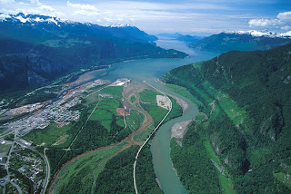

It's in an ideal location, on the delta of a river, at the end of a fjord, on the Pacific Ocean, half-way between Whistler and Vancouver. I've wondered whether I could live there, being so close to two of my favorite places, and surrounded by the mountains. With the development that has happened downtown, and with what is proposed, I feel I could. The community is starting to grow smart, sustainably. There is a new ski resort proposed for Brohm Ridge, on the north side of town. The town is surrounded by the outdoors, by nature.

That ideal location, though, also bugs me. I can't get past the fact that all of this development downtown and on the oceanfront is barely above sea level. I feel the same way about Richmond and Delta. Yes, there are dikes and pumps to keep the water out, and upgrades, improvements and expansion to both are planned, but I'm still uneasy about it all. Have we learned nothing from Galveston and New Orleans? We don't get hurricanes (yet), but we do get some good winter storms now and then, and a lot of rain all winter long. Look at London having to control the Thames, and the Netherlands having to protect almost the entire country with major flood control systems. Do we want to end up in that position? The District even admits in their preliminary document that sea level rise is a concern that will need to be addressed.

To their credit, the District of Squamish does have some design guidelines to help when there is a flood. In residential projects, the first floor (at street level) is parking and commercial. Due to the high water table, underground parking isn't an (affordable) option. But that still leaves plenty of opportunity for property damage.

So I wonder if it's possible to go even further. Let's face it, at some point there is going to be a storm bad enough to cause a flood, and if it's bad enough, the pumps are going to stop working, or the dikes won't be high enough, or both. We could:
1. Add lots of fill to raise the height of the land (very expensive)
2:Plan for a flood in a way that won't rely on emergency systems.

What if the water came in, and it wasn't really that big a deal. I'm not saying to become Venice, because it has it's own problems, after all. But what if, similar to Venice, the water stayed in canals where it belonged. What I'm picturing, in fact, is a street cross-section like Yaletown. Wide sidewalks on either side of the street that are raised about 6 feet above the road.
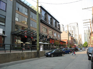


Cars drive and park on the road (and under the buildings at this same level), but pedestrians, businesses and residences are separated from and raised above it. Should the tide come over the dike or the rain come down in a deluge, the water runs into the streets (canals), which store it as needed for the pumps to keep up. Only the cars are at risk, and they can be driven to higher land should the situation call for it. The streets would function much like a stormwater retention pond, but would only be needed in the most significant storms.


At the end of each block, ramps for wheelchairs are available to access the sidewalks from the street. Spaced along the length of the block there are stairs to street level just like in Yaletown. Side streets could even be bridged at sidewalk level for pedestrians, and allowing just enough clearance for cars to get under, but keeping trucks on the main roads. Overall, the entire solution is very low-tech and much more sustainable than continuing to raise the dikes and build an infrastructure of pipes and pumps for something that should only happen a few times each century. Yaletown was born from an industrial area, and downtown Squamish and the oceanfront lands in particular are also rising out of an industrial past, so the design makes sense. Above all, it creates a great street environment, as is proven in Yaletown.

Monday, October 26, 2009

Vancouver's Downtown Streetcar


For those of you that haven't heard, the City of Vancouver is planning a downtown streetcar. "Phase 0", aka the Olympic Line, will run from Granville Island to the Olympic Village during the games, and will be free! The full plan for the future streetcar system is right here:

Downtown Streetcar Design and Alignment Report

I think this is a great idea, but I don't think it goes far enough. Why does the Pacific Blvd. line terminate at Drake and Granville? Why does it go along Drake at all? Why doesn't the line serve the West End at all? The Sky Train does a great job of serving downtown overall, but the West End is served only by buses, which are often full - a streetcar line would be a great solution and would have an immediate ridership.

Also, despite being slightly more expensive overall (yes, the capital expense is higher, but operating costs are lower), the streetcar is proving to be a preferred transit choice, as it attracts much more ridership and spurs development in the area - Portland is a great example of this. The lesson they have learned is that streetcar lines, because they are a permanent investment, are much better at generating new development than buses. A bus route could change at any moment - but once tracks for a streetcar are in place, you know it's not going away.

The city also realizes that continuing the line down Arbutus Street (along an existing rail corridor) is also an option for the future, and one that makes a lot of sense. Connections to the Millennium Skytrain Line, both current (at VCC/Clark Dr.) and the future extension along Broadway to UBC make this line even more feasible.

Anyways, here's my proposal for the future streetcar line downtown:


Routing the streetcar like this puts ALL of the downtown peninsula within a 5-10 min. walk of either a streetcar stop or a skytrain station. Streets like Davie, Denman and Robson stand to gain big benefits from having the line along them - new development at higher density (4-6 storey buildings instead of the current 1-2 storey shops), more pedestrian traffic, etc. It might make sense to take a line along Granville street to South Granville as well, because it is still a major shopping and business street, with the B-line to the airport now gone due to the Canada Line.

The line down Robson Street would work great in conjunction with its gradual conversion to a pedestrian street, particularly in the already busy Jervis-to-Seymour section. The car traffic barely moves at busy times right now, and pedestrians are nearly squeezing off the sidewalks, so closing that section to cars makes a lot of sense. This route also takes advantage of streets that are already busy transit routes, so there is guaranteed to be ridership from day one.

And in the very long term, it may make sense to take the line right over the Lion's Gate bridge to West Vancouver - but I know that's really stretching it. Even better would be a tunnel continuing the Canada Line to Lonsdale to eliminate the Seabus, and then a dedicated streetcar along the north shore linking North Vancouver and West Vancouver...but that's a topic for another day.