This is really frustrating.
In 1968, CN's Turbo Train started service and easily reached 269 km/h on its first commercial Montreal-Toronto run. Despite some technical issues, the trains operated until the 80's and the express Montreal-Toronto trip took 4 hours and routinely hit 160 km/h.
In 1982 the Turbo Trains were replaced by LRC trainsets (operated by VIA). The engines have been replaced, but the passenger cars remain in use today. They achieved a maximum speed of 208 km/h. In commercial service, however, due to limiations of the tracks and wear caused by these trainsets, they are limited to 160km/h. Today, an express Montreal-Toronto trip takes 4 hours and 30 minutes.
Does anyone else see a problem here? And this doesn't even address the fact that passenger service doesn't really even exist east of Ontario.
Tuesday, December 29, 2009
Thursday, November 5, 2009
Hockey at BC Place?

I wonder if VANOC ever thought of this: why not host the Olympic hockey finals at BC Place instead of GM Place? This is Canada, after all, and Olympic hockey tickets are as hot as, if not hotter than, opening ceremony tickets. Filling the 60,000 seats at BC Place should be easy and make them a fortune. I don't know the details of the opening/closing ceremonies, but we can be fairly certain there is going to be some sort of a temporary ice rink in there anyways for the performances at the ceremonies - so making it work for a game would be easy. The NHL has found great success now with their annual Winter Classic hockey games, so the concept is proven - and in BC Place, players wouldn't have to contend with -18C temps like they did when Edmonton hosted the Heritage Classic in 2003.
Hey VANOC - is it too late to reconsider?
Wednesday, November 4, 2009
Portland to become North America's Copenhagen?
The City of Portland, OR is setting itself a very lofty, yet attainable goal: to achieve the same level of bike ridership as Copenhagen. Right now Portland is tops in North America for bike ridership, with about 8% of all commutes by bike. By comparison, 37% of commutes in Copenhagen are by bike (and of ALL trips taken, 55% are by bike). They've done it by gradually taking away parking spots for cars (about 3%/year, which drivers don't even notice on an annual basis) and adding separated bike lanes along major arteries. Portland has already started implementing the same strategies and it's obviously working.
Bikes: Viagra for the Urban Landscape
There are a few complaints from drivers that come up of an over against making more space for bikes:
To wrap-up, some interesting facts:
Car emissions kill about 30,000 people each year in the U.S.
(American Lung Association, Oregon Traffic Commission, Association of Commuter Transportation, American Automobile Association, and City of Eugene.)
The energy and resources needed to build one medium-sized car could produce 100 bicycles.
95% of a car's energy goes towards moving the car itself, and only 5% to moving the passenger.
External costs of driving. The estimated annual external cost of driving (including air pollution, climate change, imported oil security, congestion, accidents, noise, etc.) is $126.3 billion.(E Magazine, 2005)
It costs about $50 to build and maintain one space in a bike rack and $500 for a bike locker, yet one car parking space in a typical parking structure costs about $8,500. An underground spot in a downtown Vancouver condo tower costs about $30,000 to build.
90% of children who lived within a mile of their school walked or biked to school in the 1960's. Only 31% do so today. (Salon, 2004)
Bikes: Viagra for the Urban Landscape
There are a few complaints from drivers that come up of an over against making more space for bikes:
- Bikes aren't paying for the space they use like cars are.
- We get winter here and lots of rain, so you can only bike for a few months of the year - so why are we wasting the space for bike lanes?
- Removing lanes for bikes means traffic gets worse - all those cars are sitting there are spewing more pollution than if they could move quickly.
To wrap-up, some interesting facts:
Car emissions kill about 30,000 people each year in the U.S.
(American Lung Association, Oregon Traffic Commission, Association of Commuter Transportation, American Automobile Association, and City of Eugene.)
The energy and resources needed to build one medium-sized car could produce 100 bicycles.
95% of a car's energy goes towards moving the car itself, and only 5% to moving the passenger.
External costs of driving. The estimated annual external cost of driving (including air pollution, climate change, imported oil security, congestion, accidents, noise, etc.) is $126.3 billion.(E Magazine, 2005)
It costs about $50 to build and maintain one space in a bike rack and $500 for a bike locker, yet one car parking space in a typical parking structure costs about $8,500. An underground spot in a downtown Vancouver condo tower costs about $30,000 to build.
90% of children who lived within a mile of their school walked or biked to school in the 1960's. Only 31% do so today. (Salon, 2004)
Friday, October 30, 2009
Sqaumish Oceanfront Development
Over the past two years I've been following with great interest the development of downtown Squamish and the Oceanfront lands, which were formerly industrial. As much as Squamish gets made fun of, you can't argue that it isn't incredibly beautiful.
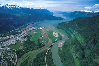
It's in an ideal location, on the delta of a river, at the end of a fjord, on the Pacific Ocean, half-way between Whistler and Vancouver. I've wondered whether I could live there, being so close to two of my favorite places, and surrounded by the mountains. With the development that has happened downtown, and with what is proposed, I feel I could. The community is starting to grow smart, sustainably. There is a new ski resort proposed for Brohm Ridge, on the north side of town. The town is surrounded by the outdoors, by nature.
That ideal location, though, also bugs me. I can't get past the fact that all of this development downtown and on the oceanfront is barely above sea level. I feel the same way about Richmond and Delta. Yes, there are dikes and pumps to keep the water out, and upgrades, improvements and expansion to both are planned, but I'm still uneasy about it all. Have we learned nothing from Galveston and New Orleans? We don't get hurricanes (yet), but we do get some good winter storms now and then, and a lot of rain all winter long. Look at London having to control the Thames, and the Netherlands having to protect almost the entire country with major flood control systems. Do we want to end up in that position? The District even admits in their preliminary document that sea level rise is a concern that will need to be addressed.
To their credit, the District of Squamish does have some design guidelines to help when there is a flood. In residential projects, the first floor (at street level) is parking and commercial. Due to the high water table, underground parking isn't an (affordable) option. But that still leaves plenty of opportunity for property damage.
So I wonder if it's possible to go even further. Let's face it, at some point there is going to be a storm bad enough to cause a flood, and if it's bad enough, the pumps are going to stop working, or the dikes won't be high enough, or both. We could:
1. Add lots of fill to raise the height of the land (very expensive)
2:Plan for a flood in a way that won't rely on emergency systems.
What if the water came in, and it wasn't really that big a deal. I'm not saying to become Venice, because it has it's own problems, after all. But what if, similar to Venice, the water stayed in canals where it belonged. What I'm picturing, in fact, is a street cross-section like Yaletown. Wide sidewalks on either side of the street that are raised about 6 feet above the road.
Cars drive and park on the road (and under the buildings at this same level), but pedestrians, businesses and residences are separated from and raised above it. Should the tide come over the dike or the rain come down in a deluge, the water runs into the streets (canals), which store it as needed for the pumps to keep up. Only the cars are at risk, and they can be driven to higher land should the situation call for it. The streets would function much like a stormwater retention pond, but would only be needed in the most significant storms.

At the end of each block, ramps for wheelchairs are available to access the sidewalks from the street. Spaced along the length of the block there are stairs to street level just like in Yaletown. Side streets could even be bridged at sidewalk level for pedestrians, and allowing just enough clearance for cars to get under, but keeping trucks on the main roads. Overall, the entire solution is very low-tech and much more sustainable than continuing to raise the dikes and build an infrastructure of pipes and pumps for something that should only happen a few times each century. Yaletown was born from an industrial area, and downtown Squamish and the oceanfront lands in particular are also rising out of an industrial past, so the design makes sense. Above all, it creates a great street environment, as is proven in Yaletown.

It's in an ideal location, on the delta of a river, at the end of a fjord, on the Pacific Ocean, half-way between Whistler and Vancouver. I've wondered whether I could live there, being so close to two of my favorite places, and surrounded by the mountains. With the development that has happened downtown, and with what is proposed, I feel I could. The community is starting to grow smart, sustainably. There is a new ski resort proposed for Brohm Ridge, on the north side of town. The town is surrounded by the outdoors, by nature.
That ideal location, though, also bugs me. I can't get past the fact that all of this development downtown and on the oceanfront is barely above sea level. I feel the same way about Richmond and Delta. Yes, there are dikes and pumps to keep the water out, and upgrades, improvements and expansion to both are planned, but I'm still uneasy about it all. Have we learned nothing from Galveston and New Orleans? We don't get hurricanes (yet), but we do get some good winter storms now and then, and a lot of rain all winter long. Look at London having to control the Thames, and the Netherlands having to protect almost the entire country with major flood control systems. Do we want to end up in that position? The District even admits in their preliminary document that sea level rise is a concern that will need to be addressed.
To their credit, the District of Squamish does have some design guidelines to help when there is a flood. In residential projects, the first floor (at street level) is parking and commercial. Due to the high water table, underground parking isn't an (affordable) option. But that still leaves plenty of opportunity for property damage.
So I wonder if it's possible to go even further. Let's face it, at some point there is going to be a storm bad enough to cause a flood, and if it's bad enough, the pumps are going to stop working, or the dikes won't be high enough, or both. We could:
1. Add lots of fill to raise the height of the land (very expensive)
2:Plan for a flood in a way that won't rely on emergency systems.
What if the water came in, and it wasn't really that big a deal. I'm not saying to become Venice, because it has it's own problems, after all. But what if, similar to Venice, the water stayed in canals where it belonged. What I'm picturing, in fact, is a street cross-section like Yaletown. Wide sidewalks on either side of the street that are raised about 6 feet above the road.

Cars drive and park on the road (and under the buildings at this same level), but pedestrians, businesses and residences are separated from and raised above it. Should the tide come over the dike or the rain come down in a deluge, the water runs into the streets (canals), which store it as needed for the pumps to keep up. Only the cars are at risk, and they can be driven to higher land should the situation call for it. The streets would function much like a stormwater retention pond, but would only be needed in the most significant storms.

At the end of each block, ramps for wheelchairs are available to access the sidewalks from the street. Spaced along the length of the block there are stairs to street level just like in Yaletown. Side streets could even be bridged at sidewalk level for pedestrians, and allowing just enough clearance for cars to get under, but keeping trucks on the main roads. Overall, the entire solution is very low-tech and much more sustainable than continuing to raise the dikes and build an infrastructure of pipes and pumps for something that should only happen a few times each century. Yaletown was born from an industrial area, and downtown Squamish and the oceanfront lands in particular are also rising out of an industrial past, so the design makes sense. Above all, it creates a great street environment, as is proven in Yaletown.
Monday, October 26, 2009
Vancouver's Downtown Streetcar

For those of you that haven't heard, the City of Vancouver is planning a downtown streetcar. "Phase 0", aka the Olympic Line, will run from Granville Island to the Olympic Village during the games, and will be free! The full plan for the future streetcar system is right here:
Downtown Streetcar Design and Alignment Report
I think this is a great idea, but I don't think it goes far enough. Why does the Pacific Blvd. line terminate at Drake and Granville? Why does it go along Drake at all? Why doesn't the line serve the West End at all? The Sky Train does a great job of serving downtown overall, but the West End is served only by buses, which are often full - a streetcar line would be a great solution and would have an immediate ridership.
Also, despite being slightly more expensive overall (yes, the capital expense is higher, but operating costs are lower), the streetcar is proving to be a preferred transit choice, as it attracts much more ridership and spurs development in the area - Portland is a great example of this. The lesson they have learned is that streetcar lines, because they are a permanent investment, are much better at generating new development than buses. A bus route could change at any moment - but once tracks for a streetcar are in place, you know it's not going away.
The city also realizes that continuing the line down Arbutus Street (along an existing rail corridor) is also an option for the future, and one that makes a lot of sense. Connections to the Millennium Skytrain Line, both current (at VCC/Clark Dr.) and the future extension along Broadway to UBC make this line even more feasible.
Anyways, here's my proposal for the future streetcar line downtown:

Routing the streetcar like this puts ALL of the downtown peninsula within a 5-10 min. walk of either a streetcar stop or a skytrain station. Streets like Davie, Denman and Robson stand to gain big benefits from having the line along them - new development at higher density (4-6 storey buildings instead of the current 1-2 storey shops), more pedestrian traffic, etc. It might make sense to take a line along Granville street to South Granville as well, because it is still a major shopping and business street, with the B-line to the airport now gone due to the Canada Line.
The line down Robson Street would work great in conjunction with its gradual conversion to a pedestrian street, particularly in the already busy Jervis-to-Seymour section. The car traffic barely moves at busy times right now, and pedestrians are nearly squeezing off the sidewalks, so closing that section to cars makes a lot of sense. This route also takes advantage of streets that are already busy transit routes, so there is guaranteed to be ridership from day one.
And in the very long term, it may make sense to take the line right over the Lion's Gate bridge to West Vancouver - but I know that's really stretching it. Even better would be a tunnel continuing the Canada Line to Lonsdale to eliminate the Seabus, and then a dedicated streetcar along the north shore linking North Vancouver and West Vancouver...but that's a topic for another day.
Thursday, October 22, 2009
An Ecotopia for Climate Protection
There are so many pessimists out there that say it just can't be done, we just can't possibly become carbon neutral, there's no way we'll make it, it's too late to stop global warming. I've never believed any of that, but evidence to refute the naysayers is hard to come by. Well here is a story that shows it is possible, and it's not hard to do or even that expensive.
An Ecotopia for Climate Protection: Samso Island Is Face of Danish Green Revolution
Samso is a small community, but cities and agricultural communities working together can become a perfect system - a balanced economy of energy that results in a net zero effect on the environment. Metro Vancouver is a perfect place to create such an economy - we have vibrant and increasingly dense, sustainable cities right next door to the most productive farmland in Canada, mountains with endlessly renewable supplies of wood and fresh water, and an ocean and all the life and energy it produces. Metro Vancouver is the perfect place to take Samso's idea and scale it to a major region.Tuesday, October 20, 2009
What to do with the viaducts

Anyone living in Vancouver knows them - the Georgia and Dunsmuir viaducts on the east end of downtown. The original Georgia viaduct was built in about 1915. It was notoriously unsafe having been built on the cheap and was finally replaced in the early 1970s with the current structures, which were part of the intended freeway plan for the city. Fortunately the rest of the freeways never got built, but these remain. With the viaducts scheduled to be closed during the duration of the Olympics in February, many are questioning how necessary they really are and what could be done to improve them assuming they are kept.
One popular idea is to tear them down. Structurally they are sound, but should a big enough earthquake occur and knock them down (a very real possibility), would we really rebuild them? The city's transportation department probably says yes, but I think the vast majority of the population begs to differ. So why are we keeping them? Councillor Geoff Meggs has written a thought provoking article for The Tyee with this very suggestion: "Time for Vancouver to Tear Down Its Viaducts?" Obviously this can't be taken lightly, as it means new connections would be needed in the road network between the higher-elevation downtown and the lower-elevation False Creek flats, but that certainly isn't impossible. Removing the viaducts frees up valuable land owned by the city for development.
How about an elevated park? Close them to regular traffic, but not tear them down. The views from the viaducts are some of the best in the city because they are elevated above the surrouding buildings and there is little development immediately around them. Using New York's High Line as an idea, why not transform these roads into raised parks with walking paths, bike lanes, gardens and more. Development around the viaducts could be promoted to work in conjunction with the parks and preserve the views.
Finally, maybe we don't tear them down and don't significantly change the viaducts, but we develop around and beside them in a way that makes them streets people want to be on. This has already been started with the Spectrum project by Concord Pacific at the west end of the viaducts. At viaduct (upper/downtown) level there are now wide sidewalks with trees fronted by townhomes. Above the townhomes are 4 - 35 storey condominium towers. The sidewalks provide access to GM Place and via stairs access to the lower level and False Creek. At the lower level. below the Spectrum towers, is parking and a full size Costco store, accessed by the "other" city grid (Expo and Pacific Blvds.) Why can't this type of development take place between the viaducts for their full length, adding wide sidewalks with townhomes and/or retail on the upper level, giving pedestrians and cyclists a reason to travel along the viaducts, and connecting the east end. On the lower level retail and offices, adding life to those streets as well. Shops and cafes on Pacific Blvd. could be sheltered by the viaduct overhead, but still get sun because they face south. They'd have a great view to the future Creekside Park. Here's a very quick sketch of what I'm trying to describe.

With the development that is soon to start happening in this area (North East False Creek), now's the time to be debating what to do with these structures. The only thing I do know for sure is that the viaducts are they are now are serving only one purpose, and not very elegantly at that. Just about anything we can do will improve them and make them an asset instead of a burden.
Thursday, October 8, 2009
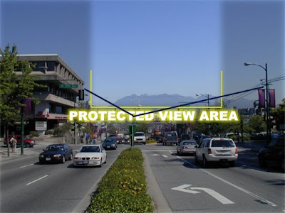
My view on "Views on Views"
On Monday night I attended "Views on Views", a lecture/debate about the current review of Vancouver's protected view corridors hosted by SFU's City Program. The discussion was lively and both sides of the argument made good points. I previously thought the view corridors in general were a good idea, but that a lot of them were pointless for how little a view they gave. After the lecture, I must admit, my "view" has changed. Here's why:
1. Although a protected view is based on standing at a certain point, and is just a glimpse from that point, views are dynamic, so as you're walking or driving along, you're seeing more than just that slim shot.
2. Most of the small glances are from along the south shore of False Creek looking towards the north shore. The downtown blocks most of the mountains, but these views give glimpses to the mountains. And lets face it, without those glimpses the monotony of the glass towers in that part of the city would be overwhelming. The views remind us where we are and distract us from what is otherwise a wall of buildings.
3. The view corridors really haven't prevented any projects from being realized, and in fact you could argue that a building like the Shangri-La ended up more beautiful because it was forced to become triangular in shape to avoid a view corridor. As an architect I can attest that the best projects are often the ones that have the most challenges, because you are forced to become even more creative than you already are. The Ritz Carlton tower also twisted the way it did in order to avoid the view corridor on it's higher levels.
4. We have a lot more land yet to develop in this city to be worried only about how much space there is downtown to continue to grow. (That was the main reason the corridors were brought up for review - to see if there was any opportunity for more and/or taller towers downtown). In particular, the area east of downtown all the way to Clark Drive was pointed out as a prime area for development, negating any need to allow bigger buildings downtown.
Those are the points that struck a chord with me. There were good arguments on the other side
as well, such as allowing buildings to go taller into the view corridors requires them to be slimmer, blocking less of the view and creating more public space at ground level. But as Larry Beasley put it best, once the views are gone, they are gone, and it only takes one building to do that.
There are still a few open houses happening before the Planning Department makes their presentation to council, so go check them out and give your opinion. Apparently there has already been a lot of support expressed for actually adding view corridors, and now is the time to do it, before downtown starts expanding east.
Open Houses:
http://www.vancouver.ca/viewsThursday, October 15: 4 - 8 pm
Saturday, October 17: 10 am – 5 pm
Sunday, October 18: 12 - 5 pm
Vancouver Public Library
Central Branch
350 West Georgia StreetTuesday, October 20: 6 - 9 pm
False Creek Elementary
900 School Green
Monday, October 5, 2009
Wednesday, September 23, 2009
Some cool facts and stats
Just a bunch of interesting facts I've come across recently...
- The Cache Creek Landfill (where Metro Vancouver's waste is taken) produces enough methane (biogas) that it could power all the trucks that ship our garbage there. Right now, though, that gas is simply burned off.
- All the Waste-to-energy plants (incinerators) in Sweden combined release fewer dioxins into the air than a single fireworks show at the Celebration of Light here in Vancouver. We have at least four of those shows a year, and yet people are worried about the emissions from additional W2E plants.
- In the US alone, in the past 30 years, over 1 trillion aluminum cans have been thrown into landfills - that aluminum is worth over $20 billion!
- North Americans have double the "ecological footprint" of Europeans and 7 times the average of Asians and Africans.
- The population of Vancouver and the Lower Fraser Valley (approx. 2 million people) depends on an area equivalent to 19 times that which is within our boundaries for our food, forestry products, carbon dioxide absorbtion and energy. What would we have to do to even cut that in half, never mind actually live within our means?
- New York City has 2.6 million street trees and 800+ community gardens that produce over 8000 lbs of fruit and vegetables a year. That's right within the city.
- There is a lot of waste we don't even see - for every 100 pounds of product manufactured in the US, approximately 3200 lbs of waste is generated.
- On average, a beer bottle is reused 15-20 times before it needs to be reprossed into new bottles! Shows how well the bottle-deposit system works.
Monday, September 14, 2009
Improving West Georgia
Since moving a few months ago I've been spending a lot more time walking along West Georgia St here in downtown Vancouver and have noticed that although parts of it are great, in general it needs some work. In fact I think this street has a ton of potential that is being missed, despite the fact that it really is the main street through downtown. It may have the ability to be to Vancouver what Michigan Ave is to Chicago. That is a lofty goal but I think West Georgia could become the "grand boulevard" that this city lacks.
The section of West Georgia from Seymour to Bute is already off to a good start with its very wide sidewalks and great buildings, but heading east, the street quickly degrades. Heading west of Bute the street is great looking, but there is little to attract pedestrians or any life other than cars. In general the street has a mix of countless types of trees but there are sections lacking any trees at all or those that do exist look pretty sad.
More than any other street in the city, West Georgia is blessed with great buildings and attractions along its length to draw people to it. We should take advantage of that fact and make it a great walking street linking those features. From east to west:
Now to make the street a grand boulevard, here's what I think needs to be done at a minimum:
The section of West Georgia from Seymour to Bute is already off to a good start with its very wide sidewalks and great buildings, but heading east, the street quickly degrades. Heading west of Bute the street is great looking, but there is little to attract pedestrians or any life other than cars. In general the street has a mix of countless types of trees but there are sections lacking any trees at all or those that do exist look pretty sad.
More than any other street in the city, West Georgia is blessed with great buildings and attractions along its length to draw people to it. We should take advantage of that fact and make it a great walking street linking those features. From east to west:
- False Creek (the connection between downtown and False Creek needs major improvement and I know the city is looking into options for that)
- GM Place and BC Place
- Queen Elizabeth Theatre
- CBC TV studio
- Vancouver Public Library - main branch
- The Hudon's Bay Company store and building
- Pacific Centre
- Vancouver Art Gallery (more on this below)
- The Hotel Vancouver
- Christ Church Cathedral
- Shangri-La building
- The Ritz Carlton (if it ever gets built)
- Several high-end residential buildings
- Stanley Park
Now to make the street a grand boulevard, here's what I think needs to be done at a minimum:
- Ensure there are trees planted along the entire length of the street and that those trees are healthy and well cared for. (In winter decorate them with lights - just google "michigan ave christmas" to see why).
- Widen and improve all the sidewalks on the east end of the street to the same width as the rest - right now they are just too narrow and in generally poor condition.
- Wherever possible (in terms of traffic volume) build a centre median to allow the planting of more trees. This would also allow for some left-turn lanes.
- Actively encourage and stimulate development on the few parking lots that remain: (between Beatty/Cambie; between Homer/Richards; SW corner at Richards; SW corner at Cardero)
- Work with Canada Post to improve the area in front of their building (ie: remove the parking).
- Extend the two-way traffic to at least Beatty Street.
Wednesday, July 29, 2009
Spinklers in every house?
This is a debate that has been going on for a while. Large buildings are sprinklered, but homes rarely are. Essentially, the cost is just too high for the perceived benefit. Here's the article that got me thinking about this a bit more:
Builders Fight proposed Home Sprinkler Requirement
Personally, I don't think there can be an absolute rule on all houses having sprinklers - after all, they are expensive. I also don't see them saving that many more lives, because the people that die now are often in old buildings and houses that don't even have a smoke alarm, never mind sprinklers. And why should a small 1200 sq.ft. house have a system when it would add a significant percentage to the cost of the home, for little benefit. A house that small is relatively cheap to rebuild should it burn down. On the other hand, the cost add sprinklers during construction of a 5000 sq.ft. mansion would be pretty insignificant, and has the potential to dramatically reduce damage by a fire. In fact I'm surprised the insurance industry isn't all over this - they have the most to gain by homes being sprinklered. I know that one of the questions insurers ask is whether your building is sprinklered or not - so surely it has an impact on premiums. And don't forget - how often is a single-family home fire ever actually contained to just that house? Rarely! With how closely spaced suburban houses are (and they aren't getting any further apart) it almost always causes damage to the neighbouring homes, either through the intense heat of the fire, or by the fire actually travelling to the next house.
To me it would make sense that any building that has more than 2 or 3 dwellings should be sprinklered. This would, for example, allow homeowners to have a rentable flat in their house without needing a sprinkler system. On the other hand, any building with more than a few dwellings, where more lives and homes could be seriously affected by a fire, should unquestionalby be sprinklered. Personally, when looking at purchasing a condo in a building, whether it is sprinklered or not weighs heavily in my decision, as spinklered, multi-tenant buildings are much safer than those that are not. The same goes for townhomes or rowhomes. Maybe two or three rowhomes adjacent to each other doesn't justify the cost...but any row of attached homes longer than that should either be sprinklered or have a full 4-hour rated firewall between each unit. Row housing was built like that in cities all over (think Montreal), and that limits the fire (and water) damage to a single unit, while still creating a dense, livable neighbourhood.
So in summary, I guess if it's your own house, and you're out in the country with no one around, why should anyone care whether your home is spinklered or not. But if you're in a city, and you have no control over your neighbour, and of course don't know what they do or how safety concious they are (or whether they are even home to announce that there is a fire), wouldn't you sleep a lot easier knowing that should a fire break out, it will be quickly extinguished by sprinklers?
Wednesday, July 15, 2009
The waste debate
As you may or may not know, Metro Vancouver is currently undergoing a review process to determine what to do with its waste in the future. The current landfill at Cache Creek is nearly full and they need to find a new solution. A new landfill has been pretty much ruled out, as had shipping the waste across the border to a facility in southern Washington - both terrible ideas to begin with.
The leading solution right now seems to be the construction of a large new waste incinerator. There is already one in the lower mainland. Now, I have little to say against waste incinerators - they are in use all over Europe and the new incinerators are very efficient and produce little air pollution. In addition, the excess heat is used to generate electricity and hot or steam to heat local buildings, resulting in a very low overall carbon footprint. Of course one large plant is only going to be able to heat so many buildings - the hot water can only go so far before it cools down to a useless temperature. So rather than one large plant, several smaller plants would make a lot more sense. Also, decentralizing the system would reduce the distance trucks had to drive to the plants.
But I fear than Metro Vancouver is getting ahead of itself. First of all, let me point out that Metro Vancouver is responsible for only about 60% of the region's waste. The other 40% goes to the Delta landfill in Delta which is owned by the City of Vancouver. Aside from Vancouver, the waste from Delta, Richmond, White Rock, the University Endowment Lands and portions of South Surrey also goes to the Delta landfill. At the current maximum authorized disposal rate, the Delta landfill could accommodate Vancouver's solid waste disposal needs for another 30 to 40 year. Of course Metro Vancouver is eyeing this landfill as a solution to their problem, but fortunately the City of Vancouver is not taking their request lightly.
Like the City of Vancouver and other municipalities, Metro needs to do more to reduce waste in the first place before charging ahead with an expensive incinerator or other mega-project solution. And if Metro indeed wants to become a Zero Waste region as they are proposing (http://www.zerowastevancouver.com), here's what they need to do first:
Seattle Transfer Station
Seattle breaks recycling record
Even better than Seattle: San Fran, New York, Portland
Then, what's left over can be disposed of as required, but must be done as efficiently as possible. Use the waste heat from an incinerator, capture the landfill gas to use for heating or power generation, etc. And don't forget - try to ship all the waste as short a distance or by as green a means as possible...see my last post about Skytrain freight. :)
The leading solution right now seems to be the construction of a large new waste incinerator. There is already one in the lower mainland. Now, I have little to say against waste incinerators - they are in use all over Europe and the new incinerators are very efficient and produce little air pollution. In addition, the excess heat is used to generate electricity and hot or steam to heat local buildings, resulting in a very low overall carbon footprint. Of course one large plant is only going to be able to heat so many buildings - the hot water can only go so far before it cools down to a useless temperature. So rather than one large plant, several smaller plants would make a lot more sense. Also, decentralizing the system would reduce the distance trucks had to drive to the plants.
But I fear than Metro Vancouver is getting ahead of itself. First of all, let me point out that Metro Vancouver is responsible for only about 60% of the region's waste. The other 40% goes to the Delta landfill in Delta which is owned by the City of Vancouver. Aside from Vancouver, the waste from Delta, Richmond, White Rock, the University Endowment Lands and portions of South Surrey also goes to the Delta landfill. At the current maximum authorized disposal rate, the Delta landfill could accommodate Vancouver's solid waste disposal needs for another 30 to 40 year. Of course Metro Vancouver is eyeing this landfill as a solution to their problem, but fortunately the City of Vancouver is not taking their request lightly.
Like the City of Vancouver and other municipalities, Metro needs to do more to reduce waste in the first place before charging ahead with an expensive incinerator or other mega-project solution. And if Metro indeed wants to become a Zero Waste region as they are proposing (http://www.zerowastevancouver.com), here's what they need to do first:
- Reduce the amount of waste generated in the first place - put limits on allowable packaging, require more returnable/refundable packages (like bottles and cans are already), etc.
- Encourage reuse of materials - construction waste is a big opportunity here; for example lumber doesn't need to be mulched or burned if it's still in good shape. Also, don't demolish buildings, deconstruct them to remove as much of the reusable materials as possible instead of everything ending up in one giant heap.
- Mandatory recycling - too many people don't recycle (or don't do it properly), and yet it's so easy to do. Implement fines for failing to properly sort waste, and set-up a waste sorting plant to catch any recyclables that make it through. At the same time, make it easy for people to do!
- Compost - people should be doing this in their yards, but those in apartments can't. Either way, set up a composting system that collects all yard and organic kitchen wastes and then turns it into compost to be put back into the ground in gardens.
- Curb-day - start an annual or semi-annual "curb-day" where people set old furniture, etc that they don't want out on the curb for others to come by and take for free. I remember doing this over 15 years ago in Waterloo, Ontario and it was a huge success. Any items that don't go can be left on the curb for pick-up the next garbage day, and hopefully recycled. Right now most of these kinds of things go straight to the landfill without any possibility of diversion. Also, encourage local community garage sales.
Seattle Transfer Station
Seattle breaks recycling record
Even better than Seattle: San Fran, New York, Portland
Then, what's left over can be disposed of as required, but must be done as efficiently as possible. Use the waste heat from an incinerator, capture the landfill gas to use for heating or power generation, etc. And don't forget - try to ship all the waste as short a distance or by as green a means as possible...see my last post about Skytrain freight. :)
Wednesday, June 24, 2009
"SkyFreight": Freight on SkyTrain? Why not?
I've been wondering if there has ever been any consideration to using SkyTrain for local shipment of goods/freight. It seems like a perfect way to increase the use of a system that is already in place, and being fully automated, would be easy to integrate into it. It would also be an additional revenue source with relatively small start-up costs since the rail lines are already there. Let's call it "SkyFreight".
"SkyFreight" cars could run independently in the gaps between passenger trains. There could be short branch lines or sections with a third track that would divert the freight lines to small depots beside the existing tracks where local trucks would pick-up and drop-off. A standardized container system would make it easy to onload and offload, and should be designed with long-distance rail in mind, so goods could be easily transferred to and from heavy rail freight trains (CN, CP).
Being able to take goods from depots on the edge of the city into the centre by "SkyFreight" would drastically reduce the number of transport trucks in the city. I can see this being a great way to ship garbage and recycling out of the inner city to a location much closer to the disposal facilities, eliminating thousands of garbage truck trips. This system would also integrate perfectly at the airport - imagine if containers could come off a plane, be rolled onto the "SkyFreight" car and be on its way without sitting in a depot. Courier services like Fedex and UPS could see a huge benefit from such a system, as they could locate depots next to train lines (in the most populated areas) and ship containers of parcels from there directly to the plane at the airport, rather than all their trucks having to drive there. Trains could run uninterupted at night when the passenger trains aren't running.
It's a very futuristic idea - automated "SkyFreight" cars (of a distinctive colour and design to differentiate from SkyTrain cars), continually shuttling goods around the lower mainland with a minimum of human input and releasing no pollutants into the air. Makes me think of scenes only seen in movies of cities of the future.
Friday, June 19, 2009
Vancouver's 2010 Streetcar

This is the first time I've heard about this Olympic Streetcar Line. Too bad they aren't testing it further along this rail line, which already exists all the way down Arbutus Street to the south side of the city. In particular, stops in Kitsilano (Burrard and 6th), at Broadway/Arbutus, and in Kerrisdale would get lots of traffic.
http://www2.bombardier.com/vancouver/index.html
Wednesday, June 17, 2009
Transport Truck of the Future
When you think about it, transport trucks (tractor-trailers, 18-wheelers, whatever you want to call them) really haven't changed much in the last 50 years. Sure they've become bigger and more powerful, but there has been no big improvement in their efficiency. With the huge mileage these trucks travel, it would make sense to develop efficient powertrains and streamline the exterior design to save fuel and money. Fuel is no doubt the truck drivers biggest expense, and with fuel costs going nowhere but up, a more efficient truck would sell itself. Of course we should also be getting more freight onto rail for long distances to reduce the number of trucks on the road. Trucks operating between a rail depot and the local area would be ideally suited to alternative powertrains such as hybrid or electric. There are hybrid buses out there already so moving that technology over to trucks should be pretty easy.
Fortunately there are companies out there working on this, and the article that inspired me to post this entry is here: The Highly Sophisticated Transporter (HST)
The transport truck is a great vehicle for a hybrid engine and green technology in general.
Fortunately there are companies out there working on this, and the article that inspired me to post this entry is here: The Highly Sophisticated Transporter (HST)
The transport truck is a great vehicle for a hybrid engine and green technology in general.
- Tons of space for batteries - less need to cram them into every nook and cranny to save valuable interior space like a car.
- A huge surface area available on which to install solar cells to help charge the battery.
- The trailer could help drive itself - motors at the wheels or even a simple drivetrain could power it as well as help charge the batteries through regenerative breaking. This would reduce the amount of power required for the tractor.
- Streamline the design. This is the simplest one of all, and I'm amazed that large trucks are still pretty much a box being pulled by a slightly more aerodynamic box. The HST shows what's possible.
Tuesday, May 26, 2009
High Speed Rail - bring on the trains!

High speed rail has been studied to death in Canada (as well as the US from what I've read) and yet there is not a single truly high speed rail line on the continent. Amtrak's Acela doesn't count in my books, because it is plagued by delays and sub-par infrastructure along it's route between Boston and Washington, DC. Theoretically, the Acela trainsets can reach an astonishing 322km/h (200mph), but due to the tracks and having to share with freight traffic, trains are limited to a maximum of 240km/h and in some sections can't travel at more than 200km/h. Overall, the average speed on an Acela trip: a sad 138km/h. Compare this to the speed record for conventional rail trains (rather than MagLev) that is currently held by France's TGV of an incredible 574.8km/h! You can see why I find it hard to call Acela "hish speed".
What's frustrating is that nearly every study that has been done, including all recent studies (say the past decade or so) say that Canada is ready for high speed rail in 3 corrdiors:
1. Quebec City-Montreal-Ottawa-Toronto-Windsor-(Detroit)
2. Calgary-Red Deer-Edmonton
3. Vancouver-Seattle-Portland
Having taken the train several times between Montreal and Toronto (which like the Acela line is rarely on time) and in a few places in Europe, I can say that it is 100 times better than flying between two cities. Heck, departing on a flight from Edmonton, you have to drive so far south to get to the airport that you may as well just keep on going to Calgary...which is what most people do.
Here are the main reasons I'm a huge fan of high speed rail:
1. It's faster. For example, Edmonton to Calgary is a 3 hour drive on a boring and very busy highway - add at least half an hour for travel by bus. A flight is only 45 minutes, but add to that checking-in an hour in advance, a 30-45 minute drive to the Edmonton Airport and 20-30 minutes from Calgary airport and you're easily over 3 hours. Compare that to a train traveling at a realistic 300km/h from downtown to downtown and you'd be there in just over an hour.
2. It's way more comfortable. Wide seats, tons of legroom, a smooth, quiet ride, no restrictions on when you can have your laptop out, cell phone reception (which I'll admit, at times isn't a good thing), the ability to get up and walk around whenever you want, real-sized bathrooms...I could go on forever. I'm not a huge Via Rail fan, but they got it right: "A more human way to travel." Also, it's been proven that a huge percentage of the general population will gladly take a train if it's available, but not a bus - you can count me on that list.
3. Zero emissions. Of course, only if it's planned for - but high speed rail is powered by electricity, which can come from solar, wind and hydro, emitting zero emissions. It's going to be a long time before we have a zero emissions jet (if ever).
4. Greater capacity in a smaller footprint. A high speed rail corridor with one track in each direction can easily handle 12,000 passengers per hour, each way, (and with higher speeds and double-decker trains that can reach 20,000). A single lane of highway is designed for a maximum of about 2250 cars/hour. What this comes down to is that a typical 6-lane highway has 13% less capacity than a standard rail system and takes up 2.5 times the land area!
5. It's friggen cool! Okay, I know this isn't quantifiable, but I guarantee that once you ride a high speed train, you'll be sold on it. Rocketing along the rails at incredible speeds and yet still being able to sit back and look at the scenery is one of the best experiences I've ever had.
For a great overview of high speed rail and even more stats, go to:
http://en.wikipedia.org/wiki/High-speed_rail
So if high speed rail is so great, why hasn't it been built here? Well, quite simply: cost. There is no question that high speed rail, while comparatively cheap to operate, has a very high initial cost and therefore must have government involvement. Many oppose the construction of high speed rail because they feel it is giving the rail line a competitive advantage to air and road travel and that taxes shouldn't be spent on such a "subsidy". But I think they forget where our airports and roads came from - our taxes. The airline and bus industries have already been subsidized for decades. The cost to build the 6-lane highway mentioned earlier through a mostly rural area is in the range of $12 million to $34 million per km (a huge range because so much depends on the location and geography of the route). The cost for the most recent high speed rail line in France (Paris-Strasbourg) came to $15.1 million per km, hardly out of touch with the comparable highway cost. Then there's the maintenance costs; the asphalt on this 6-lane highway will last a maximum of 15 years in Canada before repaving is required (at a cost of $200,000 per km), whereas the rail line is deisgned to last 100 years with minimal maintenance.
There are a ton of studies, reports and proposals out there, so it's hard to nail down which numbers are right. But overall, high speed rail wins without question. It may be an expensive investment, but it's one that will last for decades and brings big societal and environmental gains with it.
Recommended Reading:
California High Speed Rail Authority
Stop This Train!
By Tom Vanderbilt
Are trains slower now than they were in the 1920s?
(The answer is yes)
High Speed Rail in Canada
Tuesday, May 19, 2009
Edmonton's Trolley Buses Laid to Rest

When I heard a few days ago that the City of Edmonton had killed it's fleet of trolley buses, I felt a bit of sadness as well as anger. As anyone in Vancouver knows, trolley buses are much preferred over diesel buses because they are so much quieter and aren't belching out fumes. It's so nice to see and hear a trolley bus glide by, hearing only the noise of its tires and the whiz of the power collectors as they slide along the wires.
Edmonton Journal: Trolleys' last stop on road to oblivion
The City of Edmonton says that killing the remaining trolleys (they were down to 24 buses operating regularly) will save $100 million over the next 20 years. I'm not sure who they got to do their math, but that seems like a number contrived just so they can justify killing the buses. So many other cities in the world are upgrading and extending their trolley bus lines. There are even cities seriously considering bringing back their trolley fleet, but starting from scratch is expensive. Edmonton already has the basic infrastructure of overhead wires in place, so why throw all that away? They seem to have completely lost their way.
The new buses with the battery back-up don't need to stop the second their poles pop off the wire, should that happen...and they can drive off their usual route should there be an obstruction ahead. Those "unsightly" wires - that's subjective. I find them very interesting - they are such an urban statement and artists and photographers find beauty in them in the urban environment. They are a clear indication of where the bus travels, making it easier for people to see where routes go.
There are those that argue that trolley buses are no cleaner than diesel buses, because in the end, (in Alberta, at least) you're still getting power from fossil fuels, be it from a coal-fired power plant or a tank full of diesel. First, they are ignoring the quality of life benefits of trolley buses vs. diesels mentioned above. Second, they miss the point that the power could be generated without fossil fuels via wind, hydro or solar. The City of Calgary runs it's C-trains (indirectly) on wind power - why can't Edmonton (who owns the power utility EPCOR) do the same for the trolley buses? In addition, studies have shown that even in places like the Netherlands where the power is generated by a mix of coal, oil and gas, the emissions of the trolley bus, including the power generated to run it, is about 30% lower than a comparative diesel.
Trolleybus UK gives a great overview of trolley buses and the system.
With any luck, maybe the city will come to its wits and realize the true value in the trolley bus, at the very least as a tourist attraction. The city of San Francisco's streetcar line is big with tourists because it run old streetcars from around the world. The trolley bus, having been in Edmonton since 1939, has the same potential and done properly, can serve as a commuter route at the same time.
Edmonton Journal: Trolleys have tourism potential
20 years ago this may have made sense, but in 2009 this is pure ignorance on the part of the city. Edmonton: fix this mistake before it's too late.
Rome's Piazza Navona in Philadelphia?
This is the type of project we need to see in more cities. High-density, mixed use development with a great public space in the middle. It's obviously no Piazza Navona, but it sure does look great. Hopefully there are days with more than a few people in it!
See the article in the Philadelphia Inquirer
Daimler and Tesla Agreement
I think this is great news for both companies, but particularly Tesla. My Model S is looking more and more attainable each day!
See this report from AutoblogGreen
See this report from AutoblogGreen
Friday, May 15, 2009
Vancouver's View Corridors - Part 2
In yesterday's post I mentioned that I thought several of the view corridors should be modified into a v-shape. Here's an example of what I mean. I think it's a much more attractive "gap" in the buildings, and the V-shape (blue line) they would create would contrast with and accentuate the mountain peak beyond. This solution allows significantly taller buildings in many parts of downtown, while maintaining the great views.

Thursday, May 14, 2009
Vancouver's View Corridors
Vancouver is known for its compact downtown of office and residential towers, but what you may not know is why the buildings are the height they are. Looking at the skyline from a distance they all look to stop at about the same height, forming a fairly level (and some might say boring) dome-shaped skyline.

This picture is a perfect example, but you'll notice an exception, which is the new Shangri-La tower (explained below). The reason behind these building heights is view corridors. From the City of Vancouver website:
"View Protection Guidelines were approved in December 1989 and establish a number of view corridors (also known as “view cones”) over the downtown peninsula to protect views of the north shore mountains from a variety of locations south of the downtown peninsula. In February 1997 Council endorsed policies resulting from the Downtown Vancouver Skyline Study intended to result in a “dome-like” skyline shape incorporating certain key principles. In line with this decision, in May 1997 Council adopted the General Policies for Higher Buildings which outline where and under what conditions buildings higher than current maximums—up to 600 ft.—could be considered."
Not many cities have such a policy, but few cities have the natural setting that Vancouver does. That being said, downtown is such a small part of the city and region, that this does seem a bit ridiculous. Made more ridiculous by the fact that many of the view cones start from a fairly arbitrary point. The view cones limit not only the height of buildings, but also their shape, which is well represented by the triangular shape of the Shanrgi-La where the architect basically sliced off a corner of the building so as not to obscure the view.
Now in theory, this is a great policy with plenty of merit. But, those mountains in the background are over 4000' feet tall. No building or group of buildings could ever obscure their grandure. To me, some of the view cones to me are laughable while others make sense but could use some tweaking. Fortunately, the City agrees and has begun a review of all the corridors to possibly eliminate some, change others, and possibly even add some. Go visit the City's website to see all about it and to see the view corridors for yourself and why they are reviewing them.
Downtown Capacity & View Corridors Study
Study Area & Scope (here you'll see that the view cones pretty much cover all of downtown.)
View Cone List
Now the fun part - here's my opinion on each view corridor (the ones that are part of this study, at least)! Use the View Cone List to see a photo of each one.
A - Seems random and narrow, I'd scrap it
B1 - Again seems random, but it does show The Lions which are spectactular. Take the V-shaped bottom approach (see below)
B2 - You're kidding right? Scrap it.
C1 - Take the V-shaped approach.
C2 - Scrap it.
D - Mostly obscured by sailboat masts anyways - scrap it.
E1 - V-shape
E2.1 - I think there is development planned at the water's edge there - V-shape it.
3.xx - In general I like these ones - it is one of the great views in the city. I think the buildings downtown could go MUCH heigher though before they'll even begin to impact the mountain view. So I'd say raise the bottom of it significantly.
9.1 - V-shape
9.2 - V-shape or eliminate it - buildings have already cut into the view and it still looks great.
12 - This group of views generally seems pointless - very few people walk or cycle across the bridge, and they would be the ones to see the view. The cars are all whipping along at 80km/h or more, so they sure don't really need a view (and this speed and noise also explains the lack of pedestrians and cyclists travelling it).
12.1 - Scrap it
12.1.2 - Scrap it
12.1.3 - I literally laughed out loud when I saw this image - I think you know my answer.
12.2 - Now this one makes sense - being able to have that long clear view down Granville Street is pretty cool - ideally new towers that get built would help frame the view in the distance.
In general, my opinions may seem rash and illogical with little to back them up. But the way I look at it, developers want to build tall towers, people love to see, live and work in tall towers. Cities like New York and Chicago are fun, lively, vibrant cities and are known by their tall buildings. So let's allow taller (well designed, of course) buildings! It brings even more people into the city, and the opportunity for more office and work space as part of a mixed use project can't be overlooked. And if we're lucky, we'll end up with a truly landmark tower in this city some day - maybe even more than one.
Thursday, May 7, 2009
Form Shift Vancouver
I attended a lecture last night that presented the winning submissions in Form Shift. After that presentation panelists debated questions on the issues that generated the competition. What is Form Shift? Here's a description taken from clips on the site (http://formshiftvancouver.com/):
Over the past 20 years, the approach to community planning, zoning, density, transportation and housing in Vancouver has yielded substantial improvements. Continued improvement, however, requires ongoing innovation and creativity.
The City of Vancouver has developed Climate Change Action Plans as well as the EcoDensity Charter. Vancouver was the first city in Canada to adopt The 2030 Challenge for green house gas reduction. City Council has taken that commitment a step further with the stated goal of becoming “the greenest city in the world”.
FormShift Vancouver challenges you to give shape to these goals through ideas and design solutions that will help shape the future of the city...this is your chance to build a hypothetical form of the future, one that is in keeping with the vibrant, ecologically-friendly and sustainable city to which we aspire.
The post-presentation debate brought up some very interesting ideas...
- We encourage development along arterial roads (typically 4-6 stories, commercial/retail at ground level and residential above) because they are transit routes, meaning residents don't depend completely on cars. But these routes are very noisy - few people want to live on them. I can attest to this having turned down several condos while house hunting for that very reason. So how do we balance the traffic, noise and density with the desires and needs of residents?
- The suburbs are growing at a much faster rate than inner cities. How do we move more of that growth to our cities? How do we encourage people to relocate into our cities versus the suburbs? How do we work with suburban communities to help them grow smart?
- Does density = affordability?
Tuesday, May 5, 2009
Cars, Bikes and the Burrard Street Bridge
If you've never ridden a bike (or roller-bladed, or even walked, for that matter) over the Burrard Street Bridge here in Vancouver, let me try to paint a picture for you. There are 6 lanes of traffic squeezed onto the bridge with a sidewalk that is maybe 6' wide on each side. The curb feels like it's 12" above the road. Bikes and pedestrians share the bridge, (never a good combination). I compare it to riding your bike along a balance beam - that curb is a huge drop, and between trying to stay on the sidewalk and not hit pedestrians, well you can see why I avoid using that bridge at all costs - it's just no fun! The same could be said for the Granville Bridge, but for now I'll stick to the matter at hand.
I can't believe that the first (and to date, only) test for converting lanes on the Burrard Bridge to bicycle lanes was 13 years ago. That's right, 1996 - and the issue is up for debate again. That test only lasted one week (due to complaints from drivers), so the results have to be taken with a grain of salt. But even in that one week, car traffic dropped and bike traffic significantly increased. And no where in Canada is the climate better suited for cycling than southwestern BC. At long last the new city council is voting on a plan for a six month trial starting in June, and I predict a huge success.
First, I did some searching on the website of the Alliance for Biking and Walking. They have dozens of reports on all types of travel, and here are a few points that I liked most from one report, Making Cycling Irresistable, by Puncher and Buehler.
(On a side note, the "build-it-and-they-will-come" phenomenon works for cars as well. It's been shown that when, for example, a highway is widened, the overall increase in traffic ends up being much more than the capacity that was added, and in not too long traffic is actually moving slower than it was before! Clearly, building more roads is not generally the answer to traffic problems.)
Now of course drivers aren't going down without a fight here - they are worried about traffic. Traffic in Vancouver can be hell, but it's no worse than any other city in North America. In fact overall, I find it to generally be no big deal - and I've traveled to numerous major cities across the continent. Drivers here are worried that reducing lanes on the bridge will create traffic havoc. Fact is, although the first week or two may be a pain, in the long term drivers learn and overall traffic actually decreases by more than than the capacity that was taken away. In addition, I have never once been stuck in a traffic jam on Burrard Bridge itself - the problem has been the intersections and traffic lights at either end. Taking away space on the bridge shouldn't even be the issue for drivers.
The funniest thing I heard on the news today was someone from (I believe) the Downtown Business Association. Their concern is that fewer people will come downtown and business will suffer, because fewer people will want to cross a more congested bridge. Well, let's be honest here - there isn't a truly non-congested route to get to downtown as it is - so how will this make it any worse? If anything, business will increase as more cyclists from the rest of the city feel comfortable coming downtown instead of staying on the other side of False Creek. In a study done by the City of Toronto (Feb. 2009) with regards to adding bike lanes on Bloor Street, it was found that "Patrons arriving by foot and bicycle visit the most often and spend the most money per month..."
I could go on forever with facts and figures and reports and studies that show how beneficial the conversion of these lanes will be, but the best data is going to come from the actual test. Let's at least try this for 6 months and get the hard data. I think that even the drivers will be surprised at how much better this solution is. As I've said before, we can't keep growing based on the needs of cars, because that only keeps getting us into more trouble - no one can argue the fact our roads are only at capacity for a few hours out of every day. We have to look at new options - not just for the environment, but for our quality of life as well.
I can't believe that the first (and to date, only) test for converting lanes on the Burrard Bridge to bicycle lanes was 13 years ago. That's right, 1996 - and the issue is up for debate again. That test only lasted one week (due to complaints from drivers), so the results have to be taken with a grain of salt. But even in that one week, car traffic dropped and bike traffic significantly increased. And no where in Canada is the climate better suited for cycling than southwestern BC. At long last the new city council is voting on a plan for a six month trial starting in June, and I predict a huge success.
First, I did some searching on the website of the Alliance for Biking and Walking. They have dozens of reports on all types of travel, and here are a few points that I liked most from one report, Making Cycling Irresistable, by Puncher and Buehler.
- Germany, Denmark, and the Netherlands have greatly improved cycling safety since 1970. Although levels of cycling have increased in all three countries over the past 35 years, the total number of cycling fatalities has declined by over 70%. Fatalities fell by 60% in the UK over the same period, but the amount of cycling also decreased. The least improvement in cycling safety has been in the USA, where fatalities fell by only 30%.
- As the cyclist fatality rate per billion km cycled rose by 174% from 1950 to 1978, the average km cycled per inhabitant fell by 65%. Since the mid-1970s, Dutch cities have undertaken massive improvements to cycling infrastructure and restricted car use. The result has been an 81% fall in the cyclist fatality rate...thus encouraging a 36% increase in km cycled per inhabitant.
- The perceived traffic danger of cycling is an important deterrent to more widespread cycling. Women and the elderly appear to be especially sensitive to such traffic danger. Many American parents do not allow their children to cycle for the same reason.
- In the USA, much of the effort to improve cyclist safety has focused on increasing
helmet use, if necessary by law, especially for children. Thus, it is important to
emphasize that the much safer cycling in northern Europe is definitely not due to
widespread use of safety helmets. On the contrary, in the Netherlands, with the safest cycling of any country, less than one percent of adult cyclists wear helmets. - Rates of cycling are similar among different income classes. For example, the
2002 national travel survey in Germany revealed that the lowest-income quartile was
only slightly more likely to travel by bike (10% of trips) than the highest-income quartile
(8.3%) (German Federal Ministry of Transport, 2003). Similarly, cyclists are distributed
evenly among income classes in the Netherlands and Denmark (Dutch Ministry of
Transport, 2006; Dutch Cycling Federation, 2006).
(On a side note, the "build-it-and-they-will-come" phenomenon works for cars as well. It's been shown that when, for example, a highway is widened, the overall increase in traffic ends up being much more than the capacity that was added, and in not too long traffic is actually moving slower than it was before! Clearly, building more roads is not generally the answer to traffic problems.)
Now of course drivers aren't going down without a fight here - they are worried about traffic. Traffic in Vancouver can be hell, but it's no worse than any other city in North America. In fact overall, I find it to generally be no big deal - and I've traveled to numerous major cities across the continent. Drivers here are worried that reducing lanes on the bridge will create traffic havoc. Fact is, although the first week or two may be a pain, in the long term drivers learn and overall traffic actually decreases by more than than the capacity that was taken away. In addition, I have never once been stuck in a traffic jam on Burrard Bridge itself - the problem has been the intersections and traffic lights at either end. Taking away space on the bridge shouldn't even be the issue for drivers.
The funniest thing I heard on the news today was someone from (I believe) the Downtown Business Association. Their concern is that fewer people will come downtown and business will suffer, because fewer people will want to cross a more congested bridge. Well, let's be honest here - there isn't a truly non-congested route to get to downtown as it is - so how will this make it any worse? If anything, business will increase as more cyclists from the rest of the city feel comfortable coming downtown instead of staying on the other side of False Creek. In a study done by the City of Toronto (Feb. 2009) with regards to adding bike lanes on Bloor Street, it was found that "Patrons arriving by foot and bicycle visit the most often and spend the most money per month..."
I could go on forever with facts and figures and reports and studies that show how beneficial the conversion of these lanes will be, but the best data is going to come from the actual test. Let's at least try this for 6 months and get the hard data. I think that even the drivers will be surprised at how much better this solution is. As I've said before, we can't keep growing based on the needs of cars, because that only keeps getting us into more trouble - no one can argue the fact our roads are only at capacity for a few hours out of every day. We have to look at new options - not just for the environment, but for our quality of life as well.
Thursday, April 30, 2009
So what is "livability", really?
Just got back from a great lecture, "The Life and Death of Cities: Accounting for Environmental and Social Sustainability". It tied in very well with the recent release of the Mercer Quality of Living Report, in which Vancouver placed 4th in the world. The other popular report is by the Economist; World's Most Livable Cities, in which Vancouver was most recently 1st.
The Mercer report ranks based on:
The Economist World's Most Livable Cities bases its report on:
"...the challenges that might be presented to an individual's lifestyle in 140 cities worldwide. Each city is assigned a score for over 30 qualitative and quantitative factors across five broad categories: stability, health care, culture and environment, education, and infrastructure."
Now this sounds much more like a "livability" report, versus the very economically based Mercer Report.
Both reports are well summarized on Wikipedia.
But I'm still not totally clear on what livability really is. I find Vancouver incredibly livable; I wouldn't live here if I didn't. But we all like different things, so a lot of that is subjective and personal. The problem with the indexes above is that they are very numbers based and generally the numbers are too focused and not broadly defined. For example, the unemployment rate tells us how many people are working or not. But what does it tell us about those who are working? How good are their jobs? And how much are they actually working?
What about issues like urban sprawl? I don't think there is a single city in the world that can claim zero sprawl, but where in a city we live makes a huge difference on our quality of life. Generally, people move to the burbs because real estate is cheaper. But on the other hand their transportation costs are far higher, they spend huge amounts of their lives commuting, and there are clear social and community issues with everyone living in their own house separated from everyone else - never mind the cost in utilities to live that way. In which case how does Vancouver end up so highly ranked, if they are indeed ranking the region as a whole. While Vancouver proper (population 578,000) covers only 115 square km, Metro Vancouver covers a massive 2878 square km, with a population of just over 2 million; how is that livable and sustainable? The scary thing is that Vancouver is good by comparison...
Calgary: pop. 1.1 million (only slightly higher for the Metro region)
City area: 726 square km
Calgary Metro: a whopping 5107 square km!!
So on a city level that's 6 times the area for less than 2 times the population.
On a metro level that's nearly double the area for only half the population!
Toronto: pop. 2.5 million, metro 5.6 million
City area: 630 square km
Metro: 7125 square km
That's a bit smaller than Calgary but more than double the population.
On a metro level that's 5 times as many people in less than 1.5 times the area.
Compared to Vancouver, at a city level, Vancouver is about 25% more densely populated. At the metro level, Toronto is actually about 12% more dense.
Now it may seem like I'm bashing Calgary (and OK, maybe I am a little), but the scary thing is that so many cities, particularly in North America, have grown like Calgary. It's an unsustainable and poorly livable design. As more and more people move to our cities, we need to start getting this right. Over 50% of the world now lives in a city; the level is 80% in developed nations. Clearly, in the developing world there are a lot more people that will be moving to cities, because they aspire to the culture and lifestyle of the developed world. Now is the time to teach them the way, and if that means losing our status as most livable city by bringing them to greatness, it's totally worth it and the whole world will be better for it.
The Mercer report ranks based on:
- Tangible values for qualitative perceptions to establish an objective assessment of the quality of living for transfers to more than 420 cities worldwide.
- Carefully selected factors representing the criteria considered most relevant to international executives.
The Economist World's Most Livable Cities bases its report on:
"...the challenges that might be presented to an individual's lifestyle in 140 cities worldwide. Each city is assigned a score for over 30 qualitative and quantitative factors across five broad categories: stability, health care, culture and environment, education, and infrastructure."
Now this sounds much more like a "livability" report, versus the very economically based Mercer Report.
Both reports are well summarized on Wikipedia.
But I'm still not totally clear on what livability really is. I find Vancouver incredibly livable; I wouldn't live here if I didn't. But we all like different things, so a lot of that is subjective and personal. The problem with the indexes above is that they are very numbers based and generally the numbers are too focused and not broadly defined. For example, the unemployment rate tells us how many people are working or not. But what does it tell us about those who are working? How good are their jobs? And how much are they actually working?
What about issues like urban sprawl? I don't think there is a single city in the world that can claim zero sprawl, but where in a city we live makes a huge difference on our quality of life. Generally, people move to the burbs because real estate is cheaper. But on the other hand their transportation costs are far higher, they spend huge amounts of their lives commuting, and there are clear social and community issues with everyone living in their own house separated from everyone else - never mind the cost in utilities to live that way. In which case how does Vancouver end up so highly ranked, if they are indeed ranking the region as a whole. While Vancouver proper (population 578,000) covers only 115 square km, Metro Vancouver covers a massive 2878 square km, with a population of just over 2 million; how is that livable and sustainable? The scary thing is that Vancouver is good by comparison...
Calgary: pop. 1.1 million (only slightly higher for the Metro region)
City area: 726 square km
Calgary Metro: a whopping 5107 square km!!
So on a city level that's 6 times the area for less than 2 times the population.
On a metro level that's nearly double the area for only half the population!
Toronto: pop. 2.5 million, metro 5.6 million
City area: 630 square km
Metro: 7125 square km
That's a bit smaller than Calgary but more than double the population.
On a metro level that's 5 times as many people in less than 1.5 times the area.
Compared to Vancouver, at a city level, Vancouver is about 25% more densely populated. At the metro level, Toronto is actually about 12% more dense.
Now it may seem like I'm bashing Calgary (and OK, maybe I am a little), but the scary thing is that so many cities, particularly in North America, have grown like Calgary. It's an unsustainable and poorly livable design. As more and more people move to our cities, we need to start getting this right. Over 50% of the world now lives in a city; the level is 80% in developed nations. Clearly, in the developing world there are a lot more people that will be moving to cities, because they aspire to the culture and lifestyle of the developed world. Now is the time to teach them the way, and if that means losing our status as most livable city by bringing them to greatness, it's totally worth it and the whole world will be better for it.
Wednesday, April 29, 2009
A Grand Public Square for Vancouver
A few weeks ago I talked about what to do with the Sears Building in downtown Vancouver, and one of my ideas was to tear it down and build a public square big enough to host large events such as concerts, parties, rallies, etc. It's something that Vancouver is definitely lacking. Cities of the world are often defined by their squares and plazas. Rome, for example, IS its piazza's. "Meet me at Piazza Navona", actually means something. Vancouver has lots of public space along its perimeter, looking out to the mountains and ocean, but there is no major inward-looking space nor is there really any square that everyone knows. "Meet me at Emily Barnes Park", means something only to the people in the Yaletown area. We all know English Bay, but it's a huge area - how often have you tried to describe to someone on the phone where you are on English Bay? Lawn or sand; north or south; maybe at the Starbucks on the corner (which may lead to "which one?"
Anyways... go figure that there was already a design competition underway to suggest solutions to this problem called Where's the Square? (http://vancouverpublicspace.ca/index.php?page=wts_splash) The contest gave no specific site, but asked teams to suggest a site and reason why that location was best. There were numerous entries with grand squares located on the waterfront in Coal Harbour/Gastown, but to me these only add to the outward-looking public space we already have. Just to be clear, I'm not saying that view is a bad thing - it's beautiful. The other large group of entries centered around Robson Square and the Sears Building, most of them incorporating a new/improved Vancouver Art Gallery suggesting that it is much better in its current location rather than the proposed move to Plaza of Nations. This is really the place I see with the most potential. It already has huge volumes of pedestrians who would love more space, it's located at the heart of downtown, and there is a sky train station soon to be right there.
I also liked the entry that proposed a new square at Granville and Pacific/Drake. It would be a great new square in an area that is soon to be redevelopped and would only improve the attractiveness of this currently "downtrodden" area.
So go check out the short-listed entries and vote for your favourite!
http://vancouverpublicspace.ca/index.php?page=wts_gallery
On a larger scale, it would be great to see large public squares pop up all over the city and region creating a network of great spaces.
Friday, April 24, 2009
20 places to visit before they are gone...
I came across a list the other day by CNN of the 5 places to visit before they are gone due to global warming. They were great choices (and are included here in my list), but I felt there were so many more. Be it due to rising oceans, melting glaciers or toxic pollution, there are a lot of places that are at risk of disappearing within our lifetime. Yes, normally I'm the eternal optimist...but we can't ignore what is already happening. One personal example; the Athabasca Glacier in Jasper National Park has shrunk considerably since I visited it with family in 1989, and I can see the difference immediately.
So, in no particular order (other than Banff/Jasper because I think they are amazing)...and with the reason to see them soon...
1. Banff, Jasper, Yoho, Kootenay, Glacier National Parks, Canada
(Glacial melting)
In particular, a drive a long the Icefields Parkway between Banff and Jasper
2. Great Barrier Reef, Australia
(Rising ocean temperature is bleaching and killing the coral)
3. New Orleans, USA
(Rising sea levels)
I have to be honest - I wonder if rebuilding this city really makes any sense. Storms like Katrina are only becoming more common and combined with sea level rise, well...it's not rocket science.
4. Rocky Mountain National Park, USA
(Glacial melting and pine beetle infestation)
The same could be said for most of Northern BC due to the pine beetle, which has now made it over the Rockies and into Alberta, and will no doubt soon make it's way across the prairies.
5. Alpine Glaciers, Switzerland
(Glacial melting)
6. Amazon Rain Forest, Brazil
(Deforestation and desertification)
7. Venice, Italy
(Rising sea levels)
8. Alaska, USA
(Glacial melting)
9. Bali and the Indonesian Archipelago
(Rising sea levels)
10. Patagonia, Argentina
(Glacial melting)
11. Himalayan Range, Nepal
(Glacial melting)
12. The Maldives
(Rising sea levels)
13. Antarctica
(Glacial melting)
14. Glacier National Park, USA and Waterton National Park, Canada
(Glacial melting)
At the current rate, Glacier National Park will have no glaciers by 2030. Will they change the name?
15. Mount Kilimanjaro, Tanzania
(Glacial melting)
16. The Dead Sea, Israel and Jordan
(Desertification)
The water level of the Dead Sea is dropping at a rate of approx. 1 meter per year, and accelerating.
17. Miami and the Everglades, USA
(Rising sea levels)
It will only take sea levels rising by 1-2 meters for most of the tip of Florida to disappear. The same rise in ocean levels will cover Richmond and Delta, BC for those that care.
18. Galapagos Islands
(Rising sea levels)
19. Valley of the Kings and Pyramids of Giza, Egypt
(Air pollution, human development)
The pollution in the air is literally eating away at the pyramids.
20. The Netherlands
(Rising sea levels)
27% of its area and 60% of its population is located below sea level.
So that's my list - what places do you think are important to visit? I've been fortunate enough to have visited #1 and #14...and I've been to Miami but not the Everglades - so I have a lot of travelling to do!
Wednesday, April 22, 2009
Does Carbon Capture and Storage Make Sense?
There are countless ideas out there right now about how to reduce the amount of CO2 that we are sending into the atmosphere, and even removing some that is already there. There is one idea that I'm having a hard time with, and that is Carbon Capture and Storage (CCS).
Principally, CCS involves capturing the CO2 that is emitted by fossil-fuel powered electrical generation plants (coal in particular), and then storing it permanently underground or deep in the ocean. CO2 is already injected into the ground by oil companies to squeeze every drop of oil possible out of oil wells, so the process isn't new. What is new is collecting CO2 specifically to prevent it from going into the atmosphere.
Ocean storage is a very new and controvertial option because the CO2 over time eventually makes it into the atmosphere and in certain applications would dramaticlaly acidify the water, killing ocean life in the storage area. We just don't know enough about how this system would work and what effects it would have on the ocean and the planet in general.
Underground storage is clearly the safer option and is very well understood...yet it remains a less than ideal process. The main issue for me is that CCS simply buries the problem. Much like nuclear waste that will be stored forever, storing the CO2 just creates another problem. To me it makes far more sense to stop pumping out the CO2 to begin with, then we don't even have the problem. The process is still in development phase, so it's not like we can start capturing all the CO2 from power plants right away. And it's been shown that there are more than enough ways to generate the energy we need by renewable means. Here is some info about CCS:
- The UN Intergovernmental Panel on Climate Change has estimated that CCS applied to a modern power plant could capture 80-90% of the CO2 released, but to do so would consume 25-40% more fuel (coal) and the cost of electricity from said plant would increase by 21-91%!
- It is widely agreed that underground CO2 storage is safe and that 99% of stored CO2 is likely to remain underground over 1000 years with no reason it shouldn't remain there for millions of years. But what if it doesn't stay stored? What if there is a leak? CO2 is deadly in high enough concentrations. As an example, albeit a natural one: http://en.wikipedia.org/wiki/Lake_Nyos
- The government of Alberta has announced it will invest $2 billion in CCS technology. Where is the investment in what will power the province once all the oil and coal run out? At this point the government is clearly still stuck on oil and the oil companies.
Thursday, April 16, 2009
Book Review: "Traffic" by Tom Vanderbilt


If you are at all interested in traffic, drive a lot or even if you're a pedestrian, this book is a great read. You'd think a book on traffic would be boring, but it is extremely interesting. I think it's because traffic is such a huge part of our lives. We talk about it constantly, it's always in the news, we seem forever stuck in traffic jams.
Mary Roach of the New York Times puts it well: "“Traffic” is not a dry examination of highway engineering; it’s a surprising, enlightening look at the psychology of human beings behind the steering wheels." Read her full review for more.
My favorite find of Tom's research is a bit of a surprise - the "safer" the design of the intersection (lights, signs, road markings), the more accidents there are. Remove all signs and lights and leave it to drivers to make the right judgement, and accidents dissapear.
Definitely worth a read!
TRAFFIC
Why We Drive the Way We Do (And What It Says About Us)
Tom Vanderbilt
402 pp. Alfred A. Knopf.
Monday, April 13, 2009
Save the Saddledome!

Opened in 1983, the Saddledome has undergone many name changes (currently called Pengrowth Saddledome), but remains an architectural icon of Calgary and the 1988 Winter Olympics.
In typical Calgary fashion, there is now talk of the Flames building a new arena at which time the Saddledome may be demolished! That's right, 26 years (30 or so by the time this might happen) is apparently too old - disposable architecture at its worst, if you ask me. When I heard rumours of this I immediately had to find out more.
There is a great article by the Calgary Herald about the Saddledome and its entire history: "Sensational Saddledome Helped Define Calgary"
In the article, even the architect , Barry Graham won't stand up for it, saying, "I have mixed emotions. I really like the building, but I realize things don't last forever. If it has to come down, take it down."
But the building has been a hit from day one; The Saddledome hit the cover of Time magazine on Sept. 27, 1987. The construction and architectural world went ga-ga, bestowing the designers with several architectural and engineering awards.
Why would anyone demolish such a great structure? This is a building that stands out amongst the bland architecture of Calgary and of the world in general. I don't believe it will actually be demolished because it is just "too cool" for lack of a better term. But I also want to get the word out there that it is at risk! Anyways, read the article - it does a great job of telling the entire story.
Electricity vs. Hydrogen
A few weeks ago I talked about why electricity was going to become the energy of the future and not hydrogen. Here's a great article that puts numbers to both sides, and shows how much better electricity really is as a fuel.
http://www.pluginamerica.org/images/Bossel_E13.pdf
http://www.pluginamerica.org/images/Bossel_E13.pdf
Friday, April 3, 2009
Sears, Pacific Centre - A Proposal
If you live in Vancouver, and probably even if you've just visited, you know the building I'm talking about without even seeing a picture. It's that big white block on Robson between Howe and Granville - the Sears store, formerly Eaton's.
Call it weird, ugly or whatever you want, it's an excellent representation of the architecture of the 1970s. Unfortunately the white exterior (not ideally suited to a rainy, damp climate) is looking very tired and dirty because it no longer gets cleaned. Older photos of the building show it gleaming.
But the dirt is not the problem I'm proposing to fix (though it should coincide with the project). The issue I have with this building is how it almost completely turns it's back on a street that is otherwise alive with storefronts and display windows. It's a dead block on Vancouver's greatest street, having only a few entries on its exterior and not even any display windows along the sidewalk. Like all department stores of the era, and even many today, windows, and god forbid natural light, were the enemy. Even beautiful old department stores like our very own Bay on Georgia covered over all their windows in favour of "superior" artificial lighting. Have you ever seen a more dead facade than that of the Bay or similar buildings with their windows blackened? Fortunately we have now learned the error of our ways and department stores like the new Holt Renfrew are showing how it should be done, with windows and skylights all around.
Now you may think that based on the above, I don't like the Sears building. Although there was a time that I would have agreed with the masses about its ugliness, I have come to appreciate (maybe even "like") this white block. In a society where we are often too quick to say "tear it down" in order to build anew, and where only the oldest buildings are deemed to hold any historical and cultural value, we need to realize that buildings like this and of its era do have value. Buildings of the 50s, 60s and 70s are really the "heritage" buildings of today and the future. They represent the architectural and cultural beliefs of their time. The Sears building is a great example of 1970s architecture and design. I'm not saying it should be copied, but respected and learned from - and of course the reason of this article, be improved.
This proposal is really three:
- Work with the building as it stands.
- Perform a major overhaul of the building, particularly at street level.
- Demolish it. (I know this contradicts my last paragraph, but bear with me).
1. Work with the building as it stands.
![]()


As you can see in the pictures above, there is great potential to liven up this building and it's not being used. Only occasionally have I seen these large billboards used above the entry or the banners in place along the sides. The parts for everything are already there, even lighting. Such a simple project would really brighten up the otherwise plain facade. Even the City of Vancouver has recognized the potential in their redesign of Granville Street, proposing to use the east facade as a large projection screen. Oh, and of course, clean the darn facade already!
Granville Street Redesign
Design plan 1
Design plan 2
2. Perform a major overhaul
The biggest problem with this building is how it closes itself off from the street. Other than the few entrances into the store, the walls are blank, without even a display window. The first few levels of the store are busy, but up higher it's almost like a ghost town.
I propose to blast out the walls throughout the first level (maybe even the second) on all sides. Subdivide the space along the exterior into smaller retail units and of course install clear glass storefronts. These could be "shop-in-shops" or boutiques of the store's existing brands each with their own street entrance to drive traffic. Alternatively (and I think this is the better option), maintain the busiest entries into the Sears store but sublease the new spaces to other retailers. With the rents one can charge on Robson Street (and Granville and Howe for that matter) it would be a sure way to generate profit, and would also increase overall traffic. Either way, the number of doors onto the street increases, driving more traffic and making the window shopping far more interesting.
For the upper levels of the store, there are a couple of options. The first would be to combine this option with #1 and bring the exterior alive. The second would be to open up windows on the upper levels, and maybe even convert those levels to offices. Putting windows into the mainly blank facade, while maintaining the architectural integrity of the 1970s design would be a challenge, but I think it could be very successful.
3. Demolish it.
Now that I've gone on about saving this building, and what an icon it is/could be, here's an idea that is drastic, but to be honest, I think I favour.
It's a widely agreed-upon fact that Vancouver seriously lacks a true public square/event plaza. Think Nathan Phillips Square in Toronto, Olympic Plaza in Calgary, Union Square in New York, and the many smaller squares throughout downtown Montreal. For such a large, vibrant city I've always been intrigued that Vancouver lacks such a public gathering place. Plazas like this are great people watching places every day, and can host large special events like rallies, protests, concerts and fairs. Maybe even a farmers market. Nothing like this exists in Vancouver, and it's hard to argue that there is a better spot for one than where the Sears building currently sits. In conjunction with the adjacent Robson Square and Art Gallery, and its location smack in the centre of downtown, this plaza would be a winner. Here are a few examples of city squares:
![]()

![]()

Now of course the city would have to pay a pretty high price and/or work out some amazing deal with the landlord, Cadillac Fairview. But CF could still keep the lower levels of Pacific Centre Mall beneath the plaza, and theoretically could expand below the art gallery as was done in Montreal at Promenades Cathédral. To build the Promenades, the existing church on the site was temporarily lifted up while the ground beneath it was removed and the new foundation built. Entrances to the mall could be located around the perimeter of the plaza. Could the city make a trade to make this happen? It's a long shot, I'll admit, but it would result in an amazing public space in an amazing downtown.
In summary, there are a lot of options to revive this iconic, weird, ugly, beautiful building. What is your favourite idea...or do you have another one?
Subscribe to:
Posts (Atom)
