
Friday, May 15, 2009
Vancouver's View Corridors - Part 2
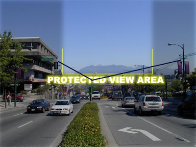
In yesterday's post I mentioned that I thought several of the view corridors should be modified into a v-shape. Here's an example of what I mean. I think it's a much more attractive "gap" in the buildings, and the V-shape (blue line) they would create would contrast with and accentuate the mountain peak beyond. This solution allows significantly taller buildings in many parts of downtown, while maintaining the great views.


Thursday, May 14, 2009
Vancouver's View Corridors
Vancouver is known for its compact downtown of office and residential towers, but what you may not know is why the buildings are the height they are. Looking at the skyline from a distance they all look to stop at about the same height, forming a fairly level (and some might say boring) dome-shaped skyline.

This picture is a perfect example, but you'll notice an exception, which is the new Shangri-La tower (explained below). The reason behind these building heights is view corridors. From the City of Vancouver website:
"View Protection Guidelines were approved in December 1989 and establish a number of view corridors (also known as “view cones”) over the downtown peninsula to protect views of the north shore mountains from a variety of locations south of the downtown peninsula. In February 1997 Council endorsed policies resulting from the Downtown Vancouver Skyline Study intended to result in a “dome-like” skyline shape incorporating certain key principles. In line with this decision, in May 1997 Council adopted the General Policies for Higher Buildings which outline where and under what conditions buildings higher than current maximums—up to 600 ft.—could be considered."
Not many cities have such a policy, but few cities have the natural setting that Vancouver does. That being said, downtown is such a small part of the city and region, that this does seem a bit ridiculous. Made more ridiculous by the fact that many of the view cones start from a fairly arbitrary point. The view cones limit not only the height of buildings, but also their shape, which is well represented by the triangular shape of the Shanrgi-La where the architect basically sliced off a corner of the building so as not to obscure the view.
Now in theory, this is a great policy with plenty of merit. But, those mountains in the background are over 4000' feet tall. No building or group of buildings could ever obscure their grandure. To me, some of the view cones to me are laughable while others make sense but could use some tweaking. Fortunately, the City agrees and has begun a review of all the corridors to possibly eliminate some, change others, and possibly even add some. Go visit the City's website to see all about it and to see the view corridors for yourself and why they are reviewing them.
Downtown Capacity & View Corridors Study
Study Area & Scope (here you'll see that the view cones pretty much cover all of downtown.)
View Cone List
Now the fun part - here's my opinion on each view corridor (the ones that are part of this study, at least)! Use the View Cone List to see a photo of each one.
A - Seems random and narrow, I'd scrap it
B1 - Again seems random, but it does show The Lions which are spectactular. Take the V-shaped bottom approach (see below)
B2 - You're kidding right? Scrap it.
C1 - Take the V-shaped approach.
C2 - Scrap it.
D - Mostly obscured by sailboat masts anyways - scrap it.
E1 - V-shape
E2.1 - I think there is development planned at the water's edge there - V-shape it.
3.xx - In general I like these ones - it is one of the great views in the city. I think the buildings downtown could go MUCH heigher though before they'll even begin to impact the mountain view. So I'd say raise the bottom of it significantly.
9.1 - V-shape
9.2 - V-shape or eliminate it - buildings have already cut into the view and it still looks great.
12 - This group of views generally seems pointless - very few people walk or cycle across the bridge, and they would be the ones to see the view. The cars are all whipping along at 80km/h or more, so they sure don't really need a view (and this speed and noise also explains the lack of pedestrians and cyclists travelling it).
12.1 - Scrap it
12.1.2 - Scrap it
12.1.3 - I literally laughed out loud when I saw this image - I think you know my answer.
12.2 - Now this one makes sense - being able to have that long clear view down Granville Street is pretty cool - ideally new towers that get built would help frame the view in the distance.
In general, my opinions may seem rash and illogical with little to back them up. But the way I look at it, developers want to build tall towers, people love to see, live and work in tall towers. Cities like New York and Chicago are fun, lively, vibrant cities and are known by their tall buildings. So let's allow taller (well designed, of course) buildings! It brings even more people into the city, and the opportunity for more office and work space as part of a mixed use project can't be overlooked. And if we're lucky, we'll end up with a truly landmark tower in this city some day - maybe even more than one.

This picture is a perfect example, but you'll notice an exception, which is the new Shangri-La tower (explained below). The reason behind these building heights is view corridors. From the City of Vancouver website:
"View Protection Guidelines were approved in December 1989 and establish a number of view corridors (also known as “view cones”) over the downtown peninsula to protect views of the north shore mountains from a variety of locations south of the downtown peninsula. In February 1997 Council endorsed policies resulting from the Downtown Vancouver Skyline Study intended to result in a “dome-like” skyline shape incorporating certain key principles. In line with this decision, in May 1997 Council adopted the General Policies for Higher Buildings which outline where and under what conditions buildings higher than current maximums—up to 600 ft.—could be considered."
Not many cities have such a policy, but few cities have the natural setting that Vancouver does. That being said, downtown is such a small part of the city and region, that this does seem a bit ridiculous. Made more ridiculous by the fact that many of the view cones start from a fairly arbitrary point. The view cones limit not only the height of buildings, but also their shape, which is well represented by the triangular shape of the Shanrgi-La where the architect basically sliced off a corner of the building so as not to obscure the view.
Now in theory, this is a great policy with plenty of merit. But, those mountains in the background are over 4000' feet tall. No building or group of buildings could ever obscure their grandure. To me, some of the view cones to me are laughable while others make sense but could use some tweaking. Fortunately, the City agrees and has begun a review of all the corridors to possibly eliminate some, change others, and possibly even add some. Go visit the City's website to see all about it and to see the view corridors for yourself and why they are reviewing them.
Downtown Capacity & View Corridors Study
Study Area & Scope (here you'll see that the view cones pretty much cover all of downtown.)
View Cone List
Now the fun part - here's my opinion on each view corridor (the ones that are part of this study, at least)! Use the View Cone List to see a photo of each one.
A - Seems random and narrow, I'd scrap it
B1 - Again seems random, but it does show The Lions which are spectactular. Take the V-shaped bottom approach (see below)
B2 - You're kidding right? Scrap it.
C1 - Take the V-shaped approach.
C2 - Scrap it.
D - Mostly obscured by sailboat masts anyways - scrap it.
E1 - V-shape
E2.1 - I think there is development planned at the water's edge there - V-shape it.
3.xx - In general I like these ones - it is one of the great views in the city. I think the buildings downtown could go MUCH heigher though before they'll even begin to impact the mountain view. So I'd say raise the bottom of it significantly.
9.1 - V-shape
9.2 - V-shape or eliminate it - buildings have already cut into the view and it still looks great.
12 - This group of views generally seems pointless - very few people walk or cycle across the bridge, and they would be the ones to see the view. The cars are all whipping along at 80km/h or more, so they sure don't really need a view (and this speed and noise also explains the lack of pedestrians and cyclists travelling it).
12.1 - Scrap it
12.1.2 - Scrap it
12.1.3 - I literally laughed out loud when I saw this image - I think you know my answer.
12.2 - Now this one makes sense - being able to have that long clear view down Granville Street is pretty cool - ideally new towers that get built would help frame the view in the distance.
In general, my opinions may seem rash and illogical with little to back them up. But the way I look at it, developers want to build tall towers, people love to see, live and work in tall towers. Cities like New York and Chicago are fun, lively, vibrant cities and are known by their tall buildings. So let's allow taller (well designed, of course) buildings! It brings even more people into the city, and the opportunity for more office and work space as part of a mixed use project can't be overlooked. And if we're lucky, we'll end up with a truly landmark tower in this city some day - maybe even more than one.
Thursday, May 7, 2009
Form Shift Vancouver
I attended a lecture last night that presented the winning submissions in Form Shift. After that presentation panelists debated questions on the issues that generated the competition. What is Form Shift? Here's a description taken from clips on the site (http://formshiftvancouver.com/):
Over the past 20 years, the approach to community planning, zoning, density, transportation and housing in Vancouver has yielded substantial improvements. Continued improvement, however, requires ongoing innovation and creativity.
The City of Vancouver has developed Climate Change Action Plans as well as the EcoDensity Charter. Vancouver was the first city in Canada to adopt The 2030 Challenge for green house gas reduction. City Council has taken that commitment a step further with the stated goal of becoming “the greenest city in the world”.
FormShift Vancouver challenges you to give shape to these goals through ideas and design solutions that will help shape the future of the city...this is your chance to build a hypothetical form of the future, one that is in keeping with the vibrant, ecologically-friendly and sustainable city to which we aspire.
The post-presentation debate brought up some very interesting ideas...
Over the past 20 years, the approach to community planning, zoning, density, transportation and housing in Vancouver has yielded substantial improvements. Continued improvement, however, requires ongoing innovation and creativity.
The City of Vancouver has developed Climate Change Action Plans as well as the EcoDensity Charter. Vancouver was the first city in Canada to adopt The 2030 Challenge for green house gas reduction. City Council has taken that commitment a step further with the stated goal of becoming “the greenest city in the world”.
FormShift Vancouver challenges you to give shape to these goals through ideas and design solutions that will help shape the future of the city...this is your chance to build a hypothetical form of the future, one that is in keeping with the vibrant, ecologically-friendly and sustainable city to which we aspire.
The post-presentation debate brought up some very interesting ideas...
- We encourage development along arterial roads (typically 4-6 stories, commercial/retail at ground level and residential above) because they are transit routes, meaning residents don't depend completely on cars. But these routes are very noisy - few people want to live on them. I can attest to this having turned down several condos while house hunting for that very reason. So how do we balance the traffic, noise and density with the desires and needs of residents?
- The suburbs are growing at a much faster rate than inner cities. How do we move more of that growth to our cities? How do we encourage people to relocate into our cities versus the suburbs? How do we work with suburban communities to help them grow smart?
- Does density = affordability?
Tuesday, May 5, 2009
Cars, Bikes and the Burrard Street Bridge
If you've never ridden a bike (or roller-bladed, or even walked, for that matter) over the Burrard Street Bridge here in Vancouver, let me try to paint a picture for you. There are 6 lanes of traffic squeezed onto the bridge with a sidewalk that is maybe 6' wide on each side. The curb feels like it's 12" above the road. Bikes and pedestrians share the bridge, (never a good combination). I compare it to riding your bike along a balance beam - that curb is a huge drop, and between trying to stay on the sidewalk and not hit pedestrians, well you can see why I avoid using that bridge at all costs - it's just no fun! The same could be said for the Granville Bridge, but for now I'll stick to the matter at hand.
I can't believe that the first (and to date, only) test for converting lanes on the Burrard Bridge to bicycle lanes was 13 years ago. That's right, 1996 - and the issue is up for debate again. That test only lasted one week (due to complaints from drivers), so the results have to be taken with a grain of salt. But even in that one week, car traffic dropped and bike traffic significantly increased. And no where in Canada is the climate better suited for cycling than southwestern BC. At long last the new city council is voting on a plan for a six month trial starting in June, and I predict a huge success.
First, I did some searching on the website of the Alliance for Biking and Walking. They have dozens of reports on all types of travel, and here are a few points that I liked most from one report, Making Cycling Irresistable, by Puncher and Buehler.
(On a side note, the "build-it-and-they-will-come" phenomenon works for cars as well. It's been shown that when, for example, a highway is widened, the overall increase in traffic ends up being much more than the capacity that was added, and in not too long traffic is actually moving slower than it was before! Clearly, building more roads is not generally the answer to traffic problems.)
Now of course drivers aren't going down without a fight here - they are worried about traffic. Traffic in Vancouver can be hell, but it's no worse than any other city in North America. In fact overall, I find it to generally be no big deal - and I've traveled to numerous major cities across the continent. Drivers here are worried that reducing lanes on the bridge will create traffic havoc. Fact is, although the first week or two may be a pain, in the long term drivers learn and overall traffic actually decreases by more than than the capacity that was taken away. In addition, I have never once been stuck in a traffic jam on Burrard Bridge itself - the problem has been the intersections and traffic lights at either end. Taking away space on the bridge shouldn't even be the issue for drivers.
The funniest thing I heard on the news today was someone from (I believe) the Downtown Business Association. Their concern is that fewer people will come downtown and business will suffer, because fewer people will want to cross a more congested bridge. Well, let's be honest here - there isn't a truly non-congested route to get to downtown as it is - so how will this make it any worse? If anything, business will increase as more cyclists from the rest of the city feel comfortable coming downtown instead of staying on the other side of False Creek. In a study done by the City of Toronto (Feb. 2009) with regards to adding bike lanes on Bloor Street, it was found that "Patrons arriving by foot and bicycle visit the most often and spend the most money per month..."
I could go on forever with facts and figures and reports and studies that show how beneficial the conversion of these lanes will be, but the best data is going to come from the actual test. Let's at least try this for 6 months and get the hard data. I think that even the drivers will be surprised at how much better this solution is. As I've said before, we can't keep growing based on the needs of cars, because that only keeps getting us into more trouble - no one can argue the fact our roads are only at capacity for a few hours out of every day. We have to look at new options - not just for the environment, but for our quality of life as well.
I can't believe that the first (and to date, only) test for converting lanes on the Burrard Bridge to bicycle lanes was 13 years ago. That's right, 1996 - and the issue is up for debate again. That test only lasted one week (due to complaints from drivers), so the results have to be taken with a grain of salt. But even in that one week, car traffic dropped and bike traffic significantly increased. And no where in Canada is the climate better suited for cycling than southwestern BC. At long last the new city council is voting on a plan for a six month trial starting in June, and I predict a huge success.
First, I did some searching on the website of the Alliance for Biking and Walking. They have dozens of reports on all types of travel, and here are a few points that I liked most from one report, Making Cycling Irresistable, by Puncher and Buehler.
- Germany, Denmark, and the Netherlands have greatly improved cycling safety since 1970. Although levels of cycling have increased in all three countries over the past 35 years, the total number of cycling fatalities has declined by over 70%. Fatalities fell by 60% in the UK over the same period, but the amount of cycling also decreased. The least improvement in cycling safety has been in the USA, where fatalities fell by only 30%.
- As the cyclist fatality rate per billion km cycled rose by 174% from 1950 to 1978, the average km cycled per inhabitant fell by 65%. Since the mid-1970s, Dutch cities have undertaken massive improvements to cycling infrastructure and restricted car use. The result has been an 81% fall in the cyclist fatality rate...thus encouraging a 36% increase in km cycled per inhabitant.
- The perceived traffic danger of cycling is an important deterrent to more widespread cycling. Women and the elderly appear to be especially sensitive to such traffic danger. Many American parents do not allow their children to cycle for the same reason.
- In the USA, much of the effort to improve cyclist safety has focused on increasing
helmet use, if necessary by law, especially for children. Thus, it is important to
emphasize that the much safer cycling in northern Europe is definitely not due to
widespread use of safety helmets. On the contrary, in the Netherlands, with the safest cycling of any country, less than one percent of adult cyclists wear helmets. - Rates of cycling are similar among different income classes. For example, the
2002 national travel survey in Germany revealed that the lowest-income quartile was
only slightly more likely to travel by bike (10% of trips) than the highest-income quartile
(8.3%) (German Federal Ministry of Transport, 2003). Similarly, cyclists are distributed
evenly among income classes in the Netherlands and Denmark (Dutch Ministry of
Transport, 2006; Dutch Cycling Federation, 2006).
(On a side note, the "build-it-and-they-will-come" phenomenon works for cars as well. It's been shown that when, for example, a highway is widened, the overall increase in traffic ends up being much more than the capacity that was added, and in not too long traffic is actually moving slower than it was before! Clearly, building more roads is not generally the answer to traffic problems.)
Now of course drivers aren't going down without a fight here - they are worried about traffic. Traffic in Vancouver can be hell, but it's no worse than any other city in North America. In fact overall, I find it to generally be no big deal - and I've traveled to numerous major cities across the continent. Drivers here are worried that reducing lanes on the bridge will create traffic havoc. Fact is, although the first week or two may be a pain, in the long term drivers learn and overall traffic actually decreases by more than than the capacity that was taken away. In addition, I have never once been stuck in a traffic jam on Burrard Bridge itself - the problem has been the intersections and traffic lights at either end. Taking away space on the bridge shouldn't even be the issue for drivers.
The funniest thing I heard on the news today was someone from (I believe) the Downtown Business Association. Their concern is that fewer people will come downtown and business will suffer, because fewer people will want to cross a more congested bridge. Well, let's be honest here - there isn't a truly non-congested route to get to downtown as it is - so how will this make it any worse? If anything, business will increase as more cyclists from the rest of the city feel comfortable coming downtown instead of staying on the other side of False Creek. In a study done by the City of Toronto (Feb. 2009) with regards to adding bike lanes on Bloor Street, it was found that "Patrons arriving by foot and bicycle visit the most often and spend the most money per month..."
I could go on forever with facts and figures and reports and studies that show how beneficial the conversion of these lanes will be, but the best data is going to come from the actual test. Let's at least try this for 6 months and get the hard data. I think that even the drivers will be surprised at how much better this solution is. As I've said before, we can't keep growing based on the needs of cars, because that only keeps getting us into more trouble - no one can argue the fact our roads are only at capacity for a few hours out of every day. We have to look at new options - not just for the environment, but for our quality of life as well.
Subscribe to:
Posts (Atom)
